First Alert Weather Day: Winter Storm Warning In The Metro Area As Arctic Blast Moves Closer
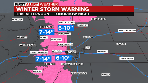
DENVER (CBS4) - The west side of the Denver metro area as well as the Boulder and Fort Collins areas have been upgraded to Winter Storm Warning because of higher expected snowfall. Most other areas in Colorado have a Winter Weather Advisory for snow and bitterly cold temperatures. That is why the CBS4 weather team has declared a First Alert Weather Day for both Tuesday and Wednesday.
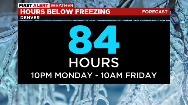
After very mild day on Monday, the official temperature in Denver dropped below freezing at 10 p.m. Monday and will stay below freezing through at least 10 a.m. Friday. In total, Denver will experience at least 84 hours with sub-freezing temperatures. It's somewhat unusual to go so long below freezing since temperatures along the Front Range of Colorado usually recover quickly after winter storms.
After the arrival of the cold, snow is up next. Denver and the Front Range will be mostly cloudy and mostly dry during the day on Tuesday. Then snow will develop in the late afternoon and early evening. Snow will be falling in most areas during the Tuesday evening commute but accumulation should initially be minor. Then after snow through the night, the Wednesday morning commute is expected to be very slow and very slick.
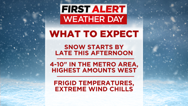
Snow will continue through the morning hours on Wednesday before gradually ending in the afternoon. By late Wednesday evening, snow is expected to to have ended in most of Colorado.
As is usually the case along the Front Range, there will be a variety of snow totals. Locations between and the foothills and I-25 including Lakewood, Littleton, Golden, Arvada, Boulder, Longmont, Loveland, and Fort Collins are expected to get 6 to 10 inches of snow. Areas above 6,000 feet in Jefferson, Boulder, and Larimer Counties will get more. These areas including Evergreen, Conifer, Black Hawk/Central City, Nederland, and Estes Park should plan on 7 to 14 inches. All of these areas are under a Winter Storm Warning from Tuesday afternoon through late Wednesday evening.
Farther to the east, there is a Winter Weather Advisory for the remainder of the Denver metro area, most of the Palmer Divide, and the Greeley area for 4 to 7 inches of snow including at the airport, downtown Denver, and the eastern and south eastern suburbs like Aurora, Brighton, and Parker.
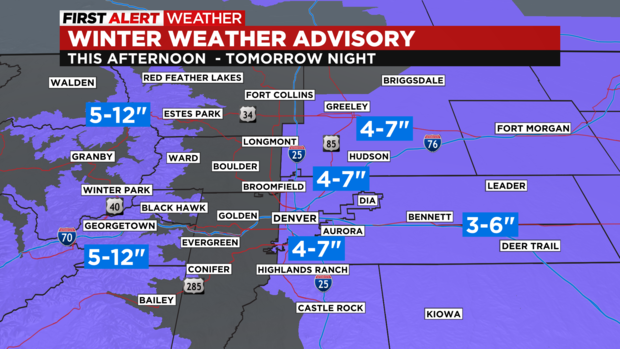
There is also a Winter Weather Advisory for the Eastern Plains for 3 to 6 inches north of I-70 and 2-4 inches south of I-70.
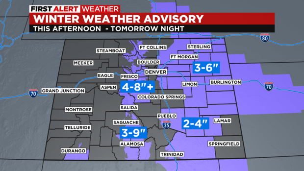
In the high county, the mountains east of Vail Pass will get 5 to 12 inches of snow with 4 to 8 inches in the mountain valleys. Mountain areas west of Vail Pass will get considerably less less snow but it's a different story for the southern mountains.
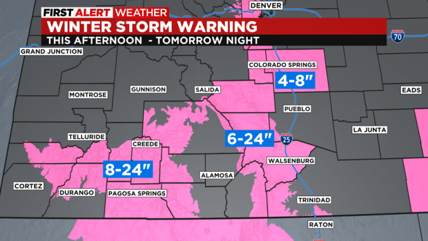
The San Juan and Sangre de Cristo Mountains are under a Winter Storm Warning for up to 2 feet of snow. Wolf Creek will probably top the list of snow at Colorado's ski areas.
After the snow ends statewide Wednesday night, Thursday will stay bitterly cold before somewhat warmer weather returns for Friday and weekend. That said, temperatures will stay below normal for early February through Sunday. The mountains should also see limited snow Saturday night while Denver and the Front Range remains dry for the weekend.
UPDATE: CDOT Says 150 New Snowplow Drivers Will Be Clearing Roads During This Winter Storm