Denver Weather: Much Cooler And Wetter Weather Coming After This Preview Of Summer
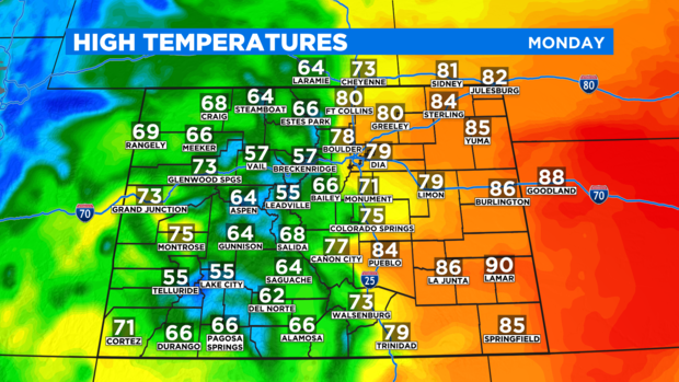
DENVER (CBS4) - Temperatures on Sunday managed to reach 80 degrees in Denver and Monday is expected to be just as warm. Then a strong cold front will bring much cooler and wetter weather for Tuesday and Wednesday. The record high temperature in Denver on Monday is 84 set on April 26, 1981. That record is safe but temperatures should be within 5 degrees of the record Monday afternoon under high cloudiness.
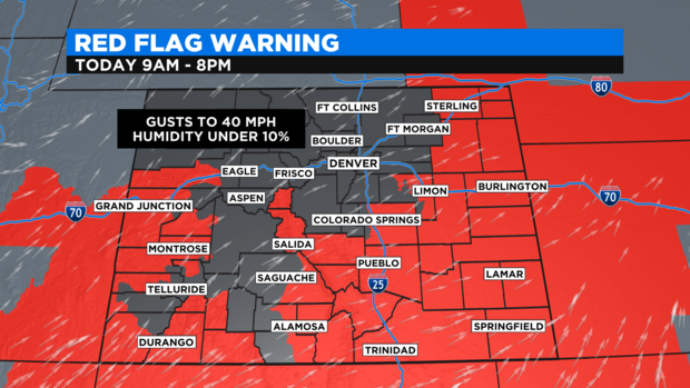
The combination of warm temperatures, low humidity, and occasionally gusty winds on Monday will also keep the fire danger high across most of the state. A Red Flag Warning is in effect through 8 p.m. for about 50% of the state including the Colorado Springs, Pueblo, Grand Junction, and Durango areas. No part of Denver or the northern Front Range is included.
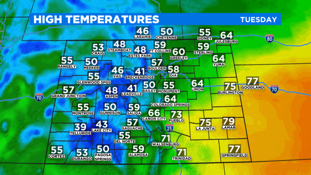
The cold front will arrive Monday night and temperatures will be at least 20 to 25 degrees cooler in most areas for Tuesday.
Unfortunately, the front will also create a lot of cloud cover which will largely block the full "pink" supermoon Monday night.
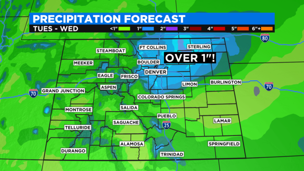
In terms of moisture, snow showers will develop in the mountains by Tuesday morning followed by rain showers east of the mountains by Tuesday afternoon. The Denver metro area should see scattered showers starting around Noon and the chance for rain will get better through the evening hours. Rain is very likely Tuesday night.
It's possible some areas in northeast Colorado receive more than 1 inch of liquid from this storm which is impressive. At this time, it seems most of the Denver, Boulder and Fort Collins areas will get 0.50-0.75" of rain.
Mountain snow will also be significant for late April with many mountain towns getting up to 6 inches of snow on Tuesday and Wednesday. Locations near the Continental Divide including ski areas that remain open like Loveland and Arapahoe Basin will get up to a foot of snow.
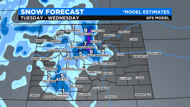
It's also possible the snow level could drop as low as 6,000 feet Wednesday morning meaning some of the western and southern suburbs of Denver could see a change to snow before the the Wednesday morning commute. At this time, no accumulation is expected outside of the mountains and higher foothills.
A few more rain showers will be possible during the day on Wednesday before the storm system moves away from Colorado Wednesday night.
Sunny, dry, and eventually much warmer weather will return for the end of the week. High temperatures will likely be well into the 80s on Saturday and it could easily be the warmest day so far this year.