Denver Weather: Approaching Snowstorm Could Be The Biggest In 9 Years
DENVER (CBS4) - Tuesday will be the fifth and final day with very mild temperatures for Denver and the entire Front Range. A transition to a very different weather pattern starts Wednesday and heavy snow is expected to start Friday.
WEDNESDAY UPDATE FROM COLORADO'S WEATHER CENTER: Historic Denver Storm On Track To Arrive Friday, Heaviest Snow Starts Friday Night
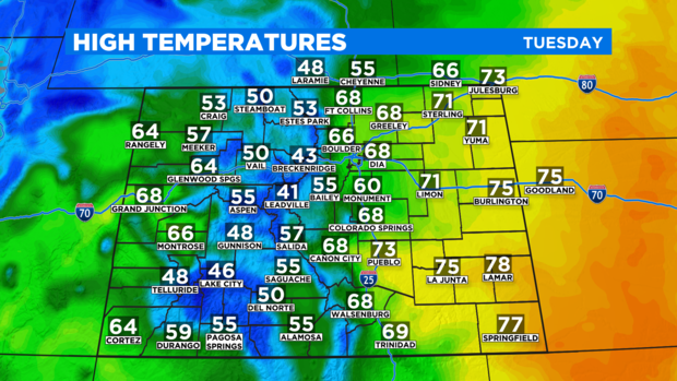
High temperatures in the metro area will reach at least the mid 60s on Tuesday which is more than 10 degrees above normal for the second week in March. Meanwhile, it feel almost like summer on the Eastern Plains with widespread 70s and some areas in southeast Colorado reaching close to 80 degrees around Lamar and Springfield.
Most mountain towns like Breckenridge, Steamboat Springs, Aspen, and Telluride will climb into the 40s and 50s.
The warm, dry, and breezy weather will also elevate the fire danger in southeast Colorado. A Red Flag Warning has been issued for communities like Canon City, Pueblo, and Lamar through 6 p.m. Tuesday for wind gusts up to 45 mph combined with relative humidity under 10%.

Cooler weather starting Wednesday with a slight chance for drizzle in the afternoon and flurries Wednesday night in the metro area. Then a chance for a light rain or snow shower develops on Thursday before a storm near the coast of Oregon Tuesday morning finally arrives in Colorado on Friday.
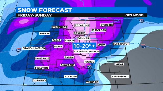
The exact track the storm takes as it travels toward the Rocky Mountains will have have a significant impact on how much snow falls along the Front Range. At a minimum, there will be several inches of snow on Friday, Saturday, and probably Sunday as well. There is no scenario where the storm completely misses Colorado.
Worst case scenarios call for the metro area measuring the snow in feet. So for snow, the CBS4 Weather Team is advertising 10-20 inches of accumulation for the Denver, Boulder, and possibility Fort Collins areas. There is the potential for less, but there is also the possibility of significantly more.
If Denver manages to get at least 16 inches of snow, it would be the biggest snowstorm in the city since February 2012 when 15.9 inches of snow feel starting on Groundhog day that year.
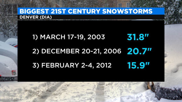
It's also possible this incoming storm could rival the first of two storms Denver experienced around Christmas 2006. That storm brought the city 20.7 inches of snow. It's unlikely Friday's storm could match the biggest storm of the last 20 years which totaled 31.8 inches in March 2003. There has only been one storm in the city's history that was bigger than 2003 and that was in December 1913 when the official measurable was 45.7 inches.
RELATED: Colorado Is Known For Heavy March Snow, One Storm Ended Record Drought In 2003
Stay with CBS4 for the latest as the storm moves closer and a more refined snow forecast becomes available.