Denver Weather: Historic Storm On Track To Arrive Friday, Heaviest Snow Starts Friday Night
DENVER (CBS4) - A small preview of what's to come caused wet streets and sidewalks Wednesday morning. It was nothing compared to the storm expected to cripple the region for the upcoming weekend.
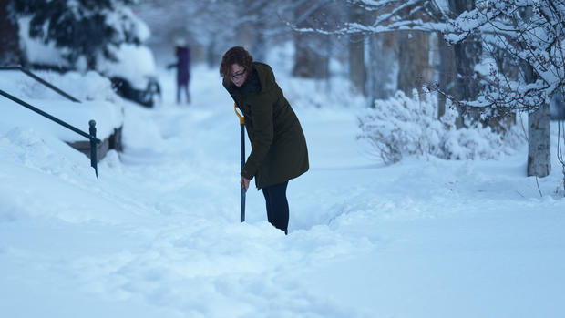
Denver officially measured 0.1" of snow early Wednesday morning as many neighborhoods experienced a mix of rain and snow. Drier weather will dominate most of the day on Wednesday but another light mix of rain and snow is possible in the metro area mainly between 5-7 p.m. Many areas will likely stay dry.
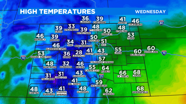
It will also be considerably cooler on Wednesday compared to recent days with high temperatures struggling to reach the lower 50s in the Denver metro area.
Looking ahead to Thursday, another chance for a light mix of rain and snow should develop in the afternoon along the Front Range and that chance will continue through Friday afternoon. Then the powerful winter storm moving from the West Coast should become close enough to Colorado to cause a surge in snow Friday night into Saturday morning. It's during this time (after midnight Friday night) when travel will start to become difficult.
Travel may eventually become impossible in many areas, conditions will become dangerous for livestock and outdoor pets, and power outages will be possible through the weekend.
The general snow forecast for Friday through Sunday is 1 to 3 feet along the Front Range. The highest amounts will be in the foothills and along the Palmer Divide in Douglas and Elbert Counties. But snowfall totals could easily exceed 12 inches even in Denver.
RELATED: Colorado Is Known For Heavy March Snow, One Storm Ended Record Drought In 2003
The two primary weather models that extend far enough into the future to capture the entire storm have some differences but both agree this will be a substantial storm.
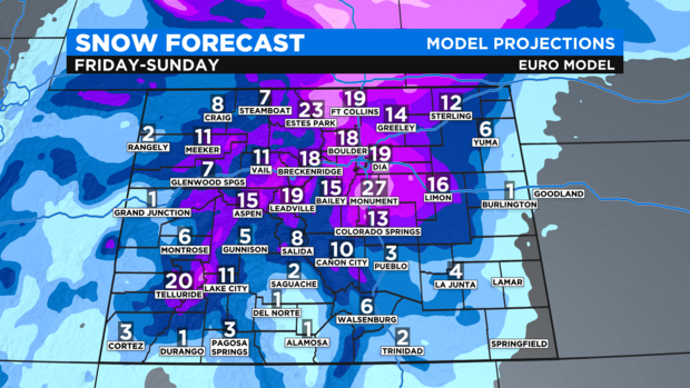
The European model has 10 to 20 inches of snow for the Denver, Boulder, and Fort Collins areas with higher amounts above 6,000 feet. These forecast numbers seem reasonable considering the strength and available moisture (this storm should produce 1.5 to 3 inches of liquid precipitation which is great news in terms of our current drought).
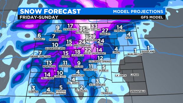
The American/GFS model has more snow than the European model for most areas except the Eastern Plains. It's suggesting at least 2 feet of snow for Denver and closer to 3 feet for some areas in Northern Colorado. While this solution is not out of the question, a projection of 33 inches of snow in Fort Collins seems too high at this time (see the map below).
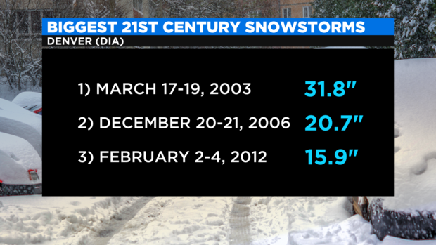
Regardless, comparisons are already being made between this storm and the biggest storms of the century so far. The most recent comparable storm was in February 2012 when Denver received almost 16 inches of snow. So it's certainly possible this incoming storm could be Denver's biggest in at least 9 years.
Some lingering snow could continue into Monday but accumulation should conclude by sunrise on Monday. Then the focus for much of next week will be chilly, below normal temperatures which should continue through at least Thursday or Friday.
RELATED: What Would It Take For Monster Weekend Snowstorm Headed For Colorado To Become A 'Blizzard'?