Snowpack Looking Good As Colorado Heads Into Dry Pattern
DENVER (CBS4) - As Colorado heads into a drier pattern this week, it's good to know our snowpack has started out strong. Early season ski conditions have been excellent, Denver measured above average November moisture, and the current snow field covers almost the entire state.
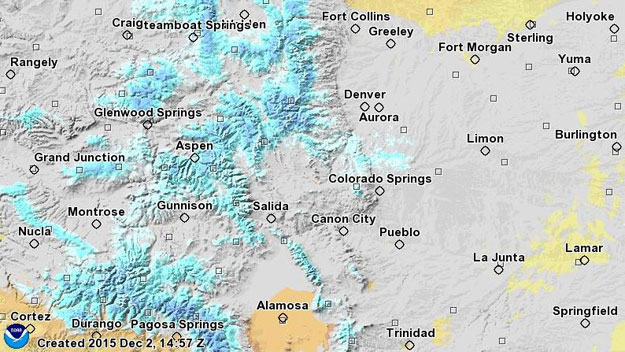
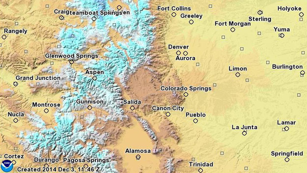
Compared to one year ago, statewide snow is more widespread and deeper for parts of the high country. Snow water equivalent maps from National Oceanic and Atmospheric Administration show the distribution of snow on Wednesday versus Dec. 2, 2014.
The Thanksgiving storm and our system on Sunday night are both responsible for the increased coverage east of the Divide. This is a welcome site for water storage in the upcoming warm season.
The moisture also brought Denver its fourth wettest November on record.
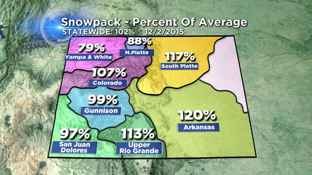
Snowpack numbers from the Natural Resources Conservation Service are above normal for the whole state. All basins averaged together, Colorado has 102 percent of its snow for this time of the year. On the high end, the Arkansas River basin has 120 percent of average.
On the low end, the Yampa and White River basins have 79 percent. The long range forecast models keep the storm track away from us until the end of next week. Sure, a couple of inches could land in the mountains between now and then, but generally the trend is quiet.
El Niño conditions aren't expected to kick into full gear until the middle of winter. For now, January and February look to be our most promising months for consistent, heavy mountain snow -- especially in southwest Colorado.
By springtime, El Niño-driven snow is supposed to back off and the atmosphere returns closer to normal. In a typical cold season, Denver's snowiest month is March with an average of 11.4" for the entire month. January is historically Denver's sixth snowiest month with only 6.6 inches on average.
We'll see what the second half of December has to offer, but in the meantime, this temporary break doesn't necessarily mean we won't see regular storms down the road.
Take the October-November transition for example.
Denver didn't even record a single inch of snow October of 2015, but November left us with 11.3"—that's 2.6" more than normal. If January ends up being El Niño's most powerful month, a lull in our present weather may help the potential energy build up even more.
Ski Report
Check the status of trails & lifts at Colorado ski resorts in the CBSDenver.com Ski Report section.
Justin McHeffey provides nightly reports from the Mobile Weather Lab. He travels Colorado in search of Mother Nature's most powerful and beautiful conditions. Like his Facebook page Meteorologist Justin McHeffey and follow him on Twitter @WeatherMcHeffey.