The Bergeron Process Will Help You Understand Why Freezing Drizzle Is Rare In Colorado
DENVER (CBS4) - Freezing rain or freezing drizzle isn't something we experience often in Colorado, especially during one of the coldest months of the year. And the way it forms is much different compared to places in the eastern and southern part of the United States.
To understand why it is so rare in Colorado we need a quick weather lesson about how we get ice inside of a cloud, also known as the Bergeron process. It requires cloud temperatures to be around -10°C (14°F) or colder.
When temperatures inside of a cloud are between -10°C (14°F) and -20°C (-4°F) we get efficient production of ice. The sweet spot for Bergeron is to have cloud temperatures between -12°C (10°F) and -16°C (3°F).
The reason for the magic number of -10°C (14°F) when it comes to the Bergeron process is because that's when we start to find ice nuclei within the atmosphere, something needed for water droplets in the cloud to bond to the nuclei and make ice. It's also when something called the saturation vapor pressure starts to maximize between water and ice. If cloud temperatures are warmer than -10°C (14°F) you can still get some ice production, but not much. The cloud will mostly produce liquid.
Wait a minute - liquid? With a cloud temperature of -10°C (14°F)? How can a cloud produce liquid when the temperature inside that cloud is well below freezing?
At some point in your school career you most likely learned that ice forms when the temperature hits 0°C, or 32°F. While true, that definition is for flat surfaces of water, such as a lake, river, puddle or pond. In a cloud, we are dealing with microscopic cloud droplets that have a spherical shape and a size around 20 micrometers. The temperature threshold to have water freeze in tiny, spherical droplets is much lower than for flat surfaces of water.
So now that you understand how freezing drizzle forms in Colorado, and why it is so rare, especially during a cold month like January, let's talk about places in the eastern and southern part of the country. When they get freezing drizzle or freezing rain it is due to a process called overrunning.
Overrunning is where a warm front moves into a region from the south. Because warm air has a lighter density than cold air, it moves up and over the cold air already in place, creating layers of air with different temperatures in the atmosphere. To visualize this think of a sandwich. The bottom bread is the cold air at the surface, the meat is the warm air from the warm front, and the top piece of bread is the cold clouds.
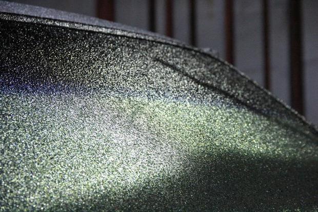
In this scenario the clouds are cold enough to make ice but the layer of warm air in between is so thick that the ice melts on the way to the ground. Because the air at the ground is still below freezing, but shallow, the liquid will not have time to refreeze. Instead, it will freeze on contact, which is called freezing drizzle or freezing rain. The difference between drizzle and rain is simply the size of the droplet.
Having a layer of warm air between the cloud and the ground is also how we get sleet, expect there is one difference. The layer of cold air near the ground in this scenario is thick enough that the liquid will completely refreeze before reaching the ground. Sleet doesn't form in a cloud, instead, it forms mid-air.