Colorado Weather: Challenging Wednesday Evening Commute Ahead With Snow And Cold In Denver
DENVER (CBS4) - A storm descending on Colorado Wednesday will send a powerful afternoon cold front across the Front Range. Temperatures will drop fast and snow will quickly spread across the entire urban corridor before the evening commute.
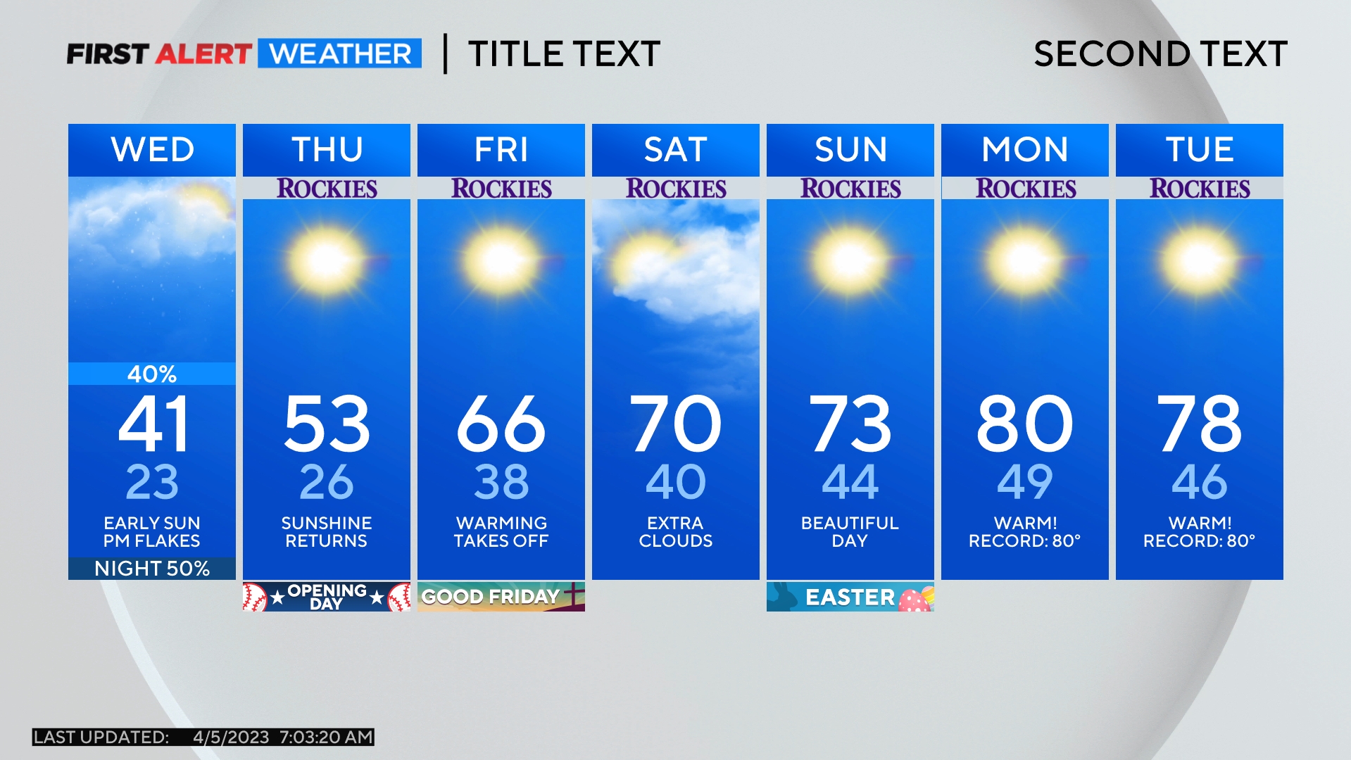
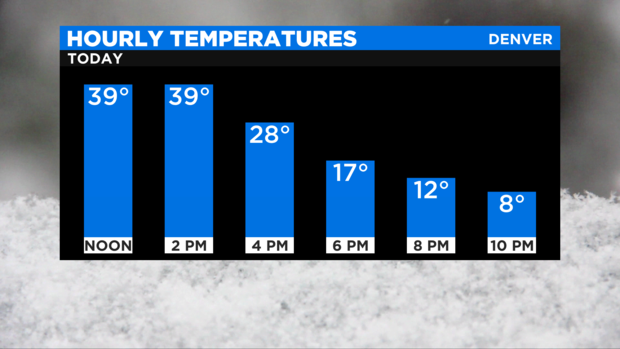
The Denver, Boulder and Fort Collins areas will climb to about 40 degrees in the early afternoon before dropping about 30 degrees in 6 hours or less as cold air invades. Temperatures will bein the single digits in the Denver metro area by the end of the evening commute.
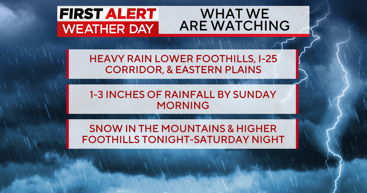
In terms of snow, the initial snow showers should develop after 1 p.m. and snow should be widespread across most of the Front Range by sunset. The heaviest snow will fall in the evening and will generally be located north of the immediate metro area.
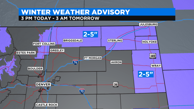
The highest snow totals outside of the high country will be near the Wyoming and Nebraska state lines. Because of this, there is a Winter Weather Advisory from 3 p.m. Wednesday until 3 a.m. Thursday from Fort Collins east to Sterling, Julesburg, Holyoke, and Wray. These locations could see up to 5 inches of snow along with wind gusts up to 35 mph.
Closer to Denver, there are no advisories but because most neighborhoods will get no more than 1-2 inches of snow but some spots could get up to 3 inches mainly north of I-70.
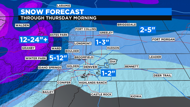
There will also be far more snow for the foothills of Boulder and Larimer County (elevations between 6,000 and 9,000 feet) including for towns like Nederland, Ward, and Estes Park. These areas have the potential of getting up to a foot of snow through early Thursday morning.
In the mountains, most ski areas will get 8 to 16 inches of total snowfall. There is a Winter Storm Warning until 12 p.m. on Thursday for the entire I-70 mountain corridor from Georgetown to Glenwood Springs.
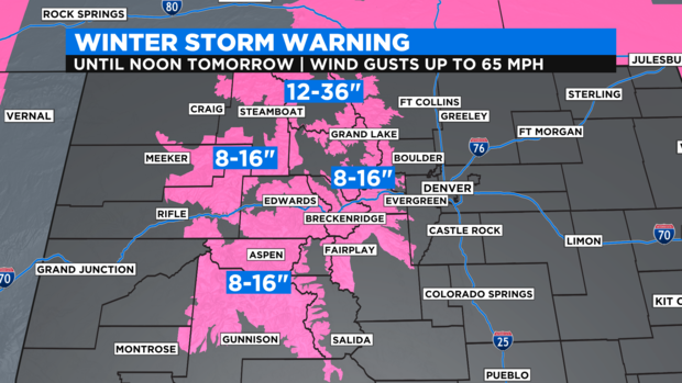
Even higher snow totals are possible in the northern mountains including around Rocky mountain National Park, Steamboat Springs, and Rabbit Ears Pass.
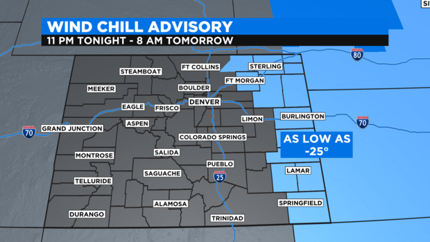
Once the snow ends in the metro area early Thursday morning, attention will turn to the bitterly cold weather. Morning temperatures will be in the single digits in the metro area and afternoon temperatures will stay below freezing.
There is also a Wind Chilly Advisory for much of the Eastern Plains Thursday morning. Wind chill values could drop as low as -25 degrees in some areas which is dangerously cold.
Much warmer weather will arrive on Friday before another storm arrives on Saturday. Snow is likely in the mountains again to start the weekend but no snow is in the Denver forecast after early Thursday morning.