'Have A Plan B': Threat Of Floating Debris Forces Closure Of Rest Areas In Glenwood Canyon
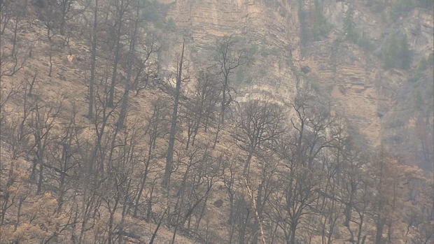
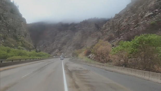
GLENWOOD SPRINGS, Colo. (CBS4) - Significant rainfall caused the closure of rest areas in Glenwood Canyon this week which the Colorado Department of Transportation says will last until the forecast improves. Continued rain over the Grizzly Creek Fire burn scar could force the closure of the entire canyon.
"This is something that could happen more often this spring only because with rain coming down on a burn scar it is more likely for debris to come down. This doesn't mean it's going to happen all the time. It's totally weather-dependent, but be prepared have a plan B," said Elise Thatcher, Region Three Communications Manager for CDOT.
The agency has been working alongside local agencies to prep for a full closure of the canyon, and just last week, warned that popular rest areas and trails could close as a preemptive measure.
"Rest areas and the recreation path will close when a minimum amount of rainfall has fallen on the Grizzly Creek Fire burn scar, or if a minimum amount of rain is in the forecast for the next 24 hours. CDOT is working with managers for Hanging Lake trail to make sure hikers have as much access as possible while still staying safe," said Thatcher.
According to the Burn Area Emergency Response Team, if a quarter inch of rain or more falls within an hour, it's enough to create significant debris flow over the Grizzly Creek burn scar.
On Monday, the rain was significant enough to keep at least the rest area closures in place.
"We want to make sure we're keeping motorists safe, and the best way to do that is to restrict access to the bike path and the rest areas," said Thatcher.
Thatcher said the planning required collaboration with not only local law enforcement, but the towns of Gypsum, east of the canyon, and Glenwood Springs to the west.
"We are preparing for whatever might happen this summer. We want to make sure that our local and regional community is as prepared as they can possibly be," said Bryana Starbuck, Public Information Officer for the city of Glenwood Springs.
Glenwood Springs is hosting a community meeting Tuesday night to inform community members about the potential impact of a full canyon closure and hosting training for frontline hospitality staff to address additional capacity needs due to stranded travelers.
"If you do get to enjoy your stay longer with us than there's lots to do and we're excited see everyone," she said.
In a news release CDOT emphasized the importance of paying attention to forecasts and outlined a safe detour in the event of a full closure:
Motorists planning to travel on I-70, visit rest areas or use the recreation path in Glenwood Canyon should pay close attention to weather forecasts. If there is rain in the forecast, be prepared for a safety closure of I-70, rest areas and recreation path. CDOT recommends that travelers have a backup plan in the event that closures are necessary. Motorists should be familiar with the recommended alternate route (more information below) and should check www.cotrip.org for the latest road conditions and route options. CDOT also recommends that travelers bring an emergency kit with water, snacks, a flashlight and a blanket, as mountain conditions often change suddenly.
What alternate route should I take during an I-70 closure in Glenwood Canyon?
If a safety closure of I-70 in Glenwood Canyon is anticipated to last longer than two hours, CDOT recommends a northern alternate route using Colorado Highway 9, US Highway 40 and Colorado Highway 13. This alternate route is not the same as the 2020 detour. Motorists should anticipate delays on the alternate route due to additional detour traffic.• WESTBOUND I-70: Motorists coming from the Denver metro area or Interstate 25 can travel westbound on I-70 to Silverthorne, then turn north onto CO 9. In Kremmling, travelers should turn onto westbound US Highway 40 towards Steamboat Springs. After reaching Craig, motorists can return south via CO 13 towards Rifle. Access to I-70 westbound is at Rifle.
• EASTBOUND I-70: Motorists traveling eastbound from Utah or Grand Junction can reach the Denver Metro area by traveling the route above in reverse. CO 13 north to US 40 east to CO 9 south.
CDOT strongly discourages travelers from using highways south of I-70 for an alternate route, due to extensive construction closures. CDOT also asks that motorists not use Cottonwood Pass Road (in Eagle/Garfield counties), Hagerman Pass, Eagle/Thomasville Road or other county or forest service roads in Eagle, Garfield and Pitkin counties as a detour. These roads are not built for heavy traffic or commercial oversize vehicles. Many of these four-wheel drive roads also do not have cell phone coverage.