Denver Weather: Massive Snowstorm Is Slowing Down, And Projected Snow Totals Are Trending Up
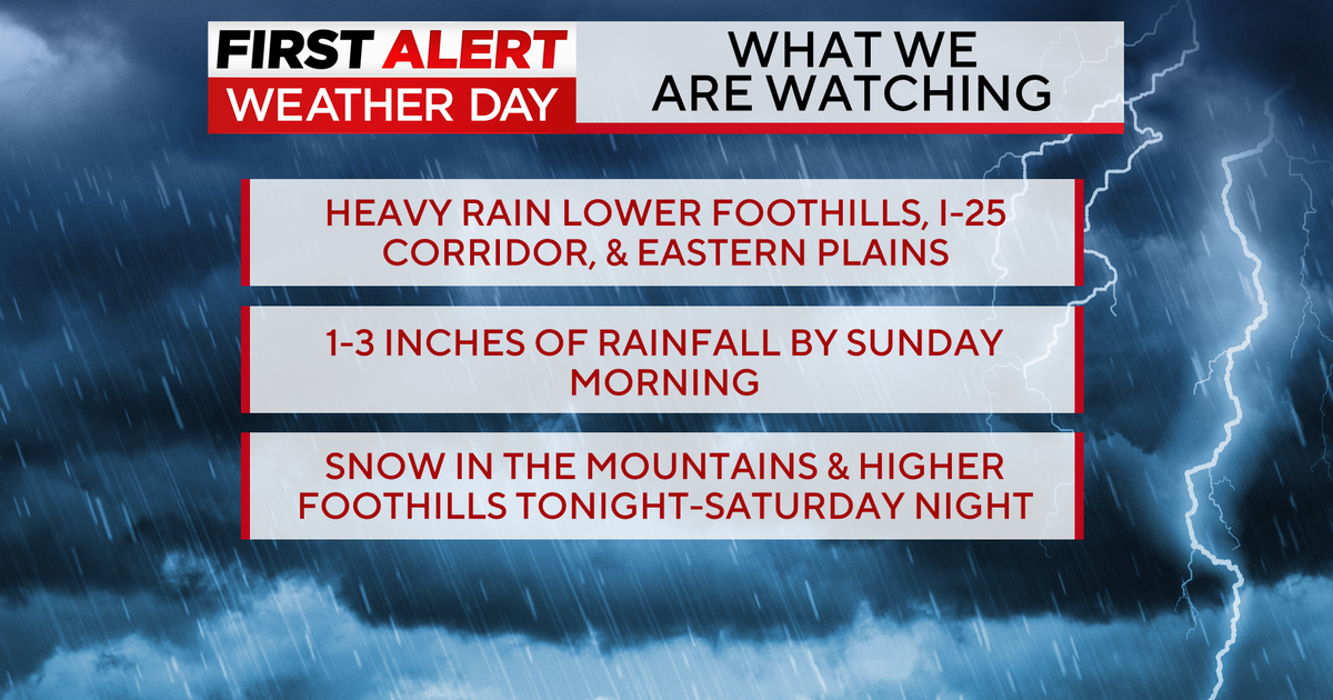
DENVER (CBS4) - The powerful storm expected to bring historic snowfall to Denver and a large portion of Colorado this weekend has slowed down. The slow pace will contribute to enormous accumulation in many areas starting late Friday night.
The entire I-25 urban corridor from Colorado Springs to Denver to Cheyenne is under a Winter Storm Watch starting at midnight Friday night through midnight Sunday night. The I-70 mountain corridor between Denver and Avon is also under a Winter Storm Watch starting at 5 p.m. Friday.
The highest snow totals in Colorado will be over the higher peaks and mountain passes with at least 36-48 inches of snow possible over Berthoud and Loveland Passes as well the I-70 approaches to the Eisenhower Tunnel.
For much of the Denver metro area, a total of 15 to 25 inches of snow is expected with about half piling up by Saturday night and the remainder falling on Sunday. Even higher amounts are possible in Boulder and Fort Collins with totals reaching near 30 inches in some areas.
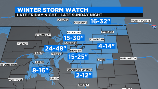
Accumulation will be less south of Monument Hill with 2 to 12 inches expected in the Colorado Springs area (higher amounts west and north, lower totals east and south of the city). Meanwhile, even higher snow totals are expected along the I-80 corridor in southwest Wyoming and western Nebraska with up to 32 inches between Laramie, WY and Sidney, NE.
The snow will also contain a lot of moisture. A total of up to 5 inches of liquid precipitation will fall with this storm. Therefore the snow will be heavy and wet. It will be excellent snow for building snowmen but it will also be the type of snow that tends to break branches and causes power outages.
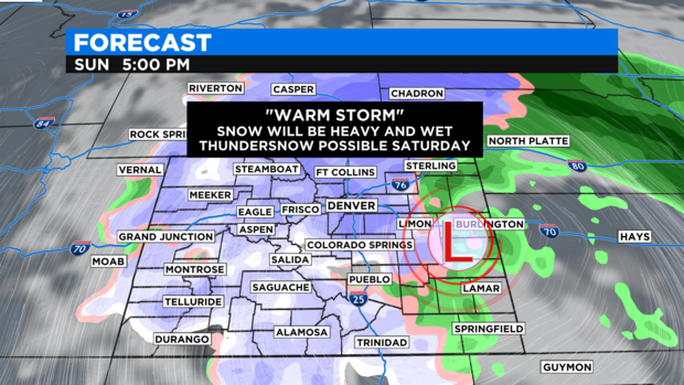
It will also be a "warm storm" since it originated in the Pacific Ocean instead of Canada. Therefore there will be no big surge of cold air. High temperatures on Saturday and Sunday will hover near freezing in the Denver metro area and could stay above freezing on much of the Eastern Plains meaning precipitation could stay mainly rain especially east of Fort Morgan, Limon, and La Junta.
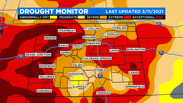
The good news is regardless of what type of precipitation falls in specific areas, it is very welcomed moisture. The weekly drought monitor released Thursday morning showed zero improvement for Colorado in the last 7 days. About 99% of the state is still experiencing moderate drought, 89% of the state has at least severe drought, and 57% of Colorado has at least extreme drought.
The relatively warm temperatures also means there could be a few thunderstorms that produce thundersnow on Saturday. Most of the thunderstorms should stay far east of the urban corridor but it's possible a storm could get close to the east side of the metro area and even produce hail.
Obviously this is very complex storm!
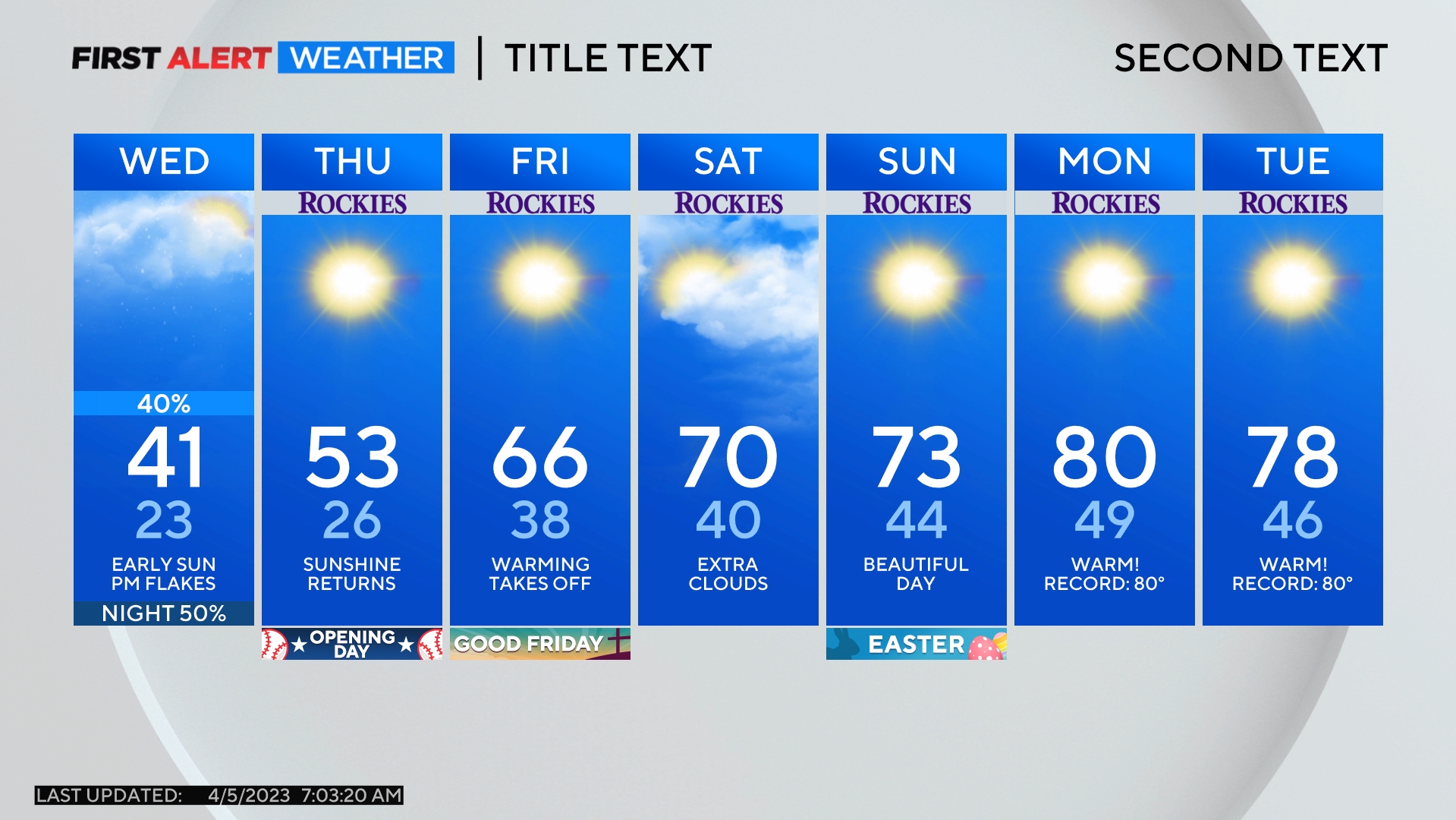
By Monday morning, the storm should be far enough to the east for the snow to end in the metro area. Our attention will then shift to chilly temperatures that will remain in place all week. A few more light snow showers should also be possible on Tuesday and maybe Wednesday as well.