Colorado Weather: 100 MPH Winds Slam The Loveland And Berthoud Area
DENVER (CBS4) - A weather station just north of Carter Lake at the base of the foothills in Larimer County clocked a 100 mph wind gust around 2:30 a.m. Tuesday. It was the strongest gust produced by the latest wind event to hit to Colorado.
Gusts routinely reached over 65 mph Monday night and Tuesday morning in and near the foothills in Jefferson, Boulder, and Larimer Counties. At the intersection of Highway 93 and Highway 72 near Rocky Flats winds reached 80 mph and gusts reached at least 70 mph in Genesee and Glen Haven near Estes Park.
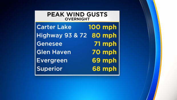
Hurricane force wind starts at 74 mph and the 100 mph gust at Carter Lake was the equivalent of a Category 2 hurricane.
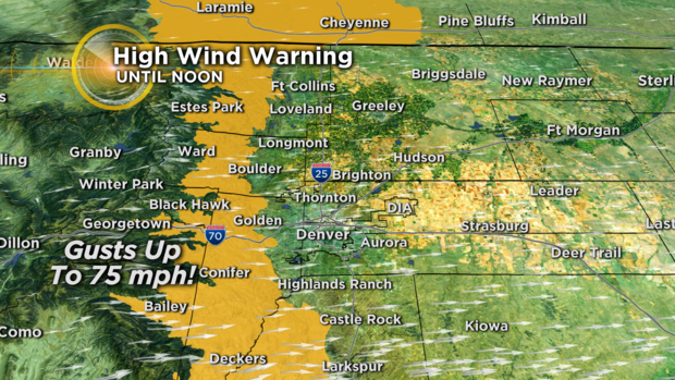
More very strong wind gusts are expected mainly in and near the foothills through the morning on Tuesday. A HIGH WIND WARNING is set to expire at 12 p.m.
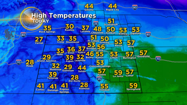
It will also be breezy at times in the Denver metro area on Tuesday but wind speeds will stay far lighter than the wind in the foothills. However, there should be enough wind to push temperatures into the lower and middle 50s around Denver, Boulder, and Fort Collins which is 10 to 15 degrees warmer compared to Sunday and Monday.
Another relatively mild day is on tap for Wednesday before colder weather returns for Thursday and Friday along with snow showers mainly in the mountains.