Colorado Weather: Potentially Historic Spring Snow Storm Arrives Thursday Night
DENVER (CBS4) - A cold front that originated in Alaska will reach Colorado Thursday night. Before the front arrives, it will be very dry, very warm, and very windy at times causing critical fire danger.
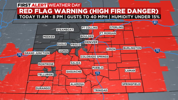
The CBS4 Weather Team has declared Thursday a First Alert Weather Day because of fire danger and Friday a First Alert Weather Day because of cold, rain, and snow.
Almost the entire state of Colorado has a Red Flag Warning from 11 a.m. until 8 p.m. Thursday including the Denver metro area. Westerly winds gusting up to 40 mph together with with very dry air and unusually hot temperatures will push fire danger into the critical category. If a fire were to start on Thursday, it could grow very quick and be difficult for firefighters to control. Any outdoor activity that could produce a spark should be avoided through Thursday evening.
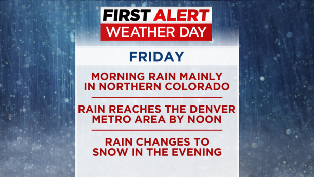
After the cold front arrives, attention will quickly go from fire danger to truly winter style weather. Snow will spread over the northern mountains of Colorado by early Friday morning and rain should develop around Fort Collins, Loveland and Greeley by daybreak on Friday.
The rain will then gradually move south toward the Denver metro area through midday while the snow in the mountains as well as the foothills of Boulder and Larimer Counties intensifies.
The heaviest snow in the high country is expected to be around Rocky Mountain National Park including Estes Park, Glendevey, Ward, Nederland and Red Feather Lakes. These areas should measure 12 to 24 inches of snow along with with wind gusts up to 35 mph -- making for difficult or impossible travel. The I-80 corridor in Wyoming west of Cheyenne is also under a Winter Storm Warning for 5-12 inches of snow.
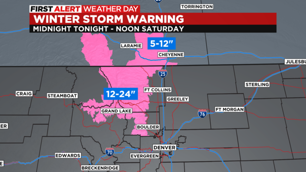
Elsewhere is there is a Winter Storm Watch including the Denver, Boulder and Fort Collins areas. Snow totals are far from certain and there will likely be large variety of snow amounts depending on when the shift from rain to snow happens in specific areas and how much snow melts before the ground is cold enough to support accumulation.
The expected timeline for the urban corridor is rain by sunrise on Friday around Fort Collins, Loveland and Greeley. Then rain will then move south toward the Denver metro area by around midday and rain showers are expected through the afternoon hours and probably into the evening commute as well. Eventually the rain will mix with snow and then change into all snow Friday night through Saturday morning before changing back into rain later in the day on Saturday.
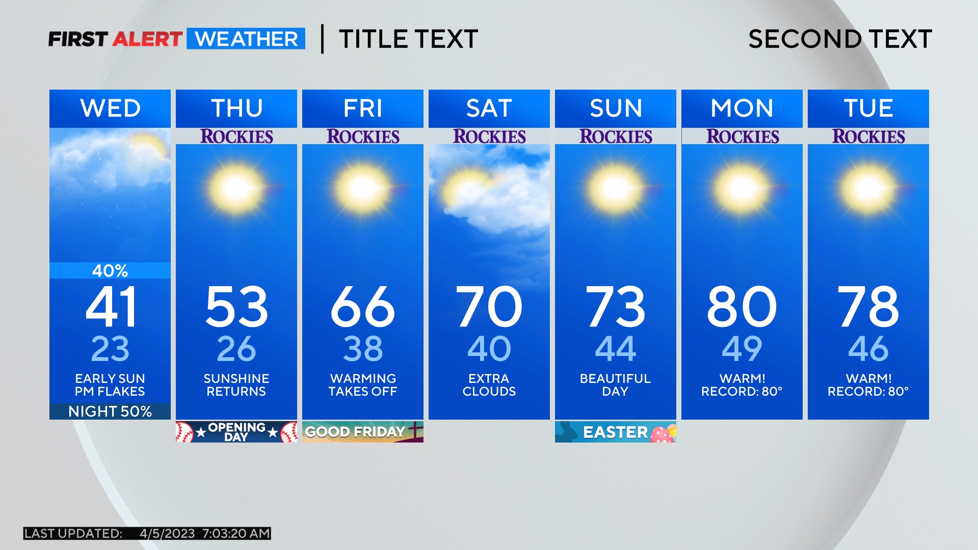
The potential exists for at least 4 inches of slushy snow in Denver which would be the most snow this late in the season since May 29, 1975.
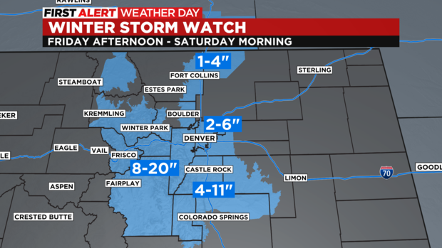
Without a doubt, the most significant impacts in terms of travel conditions, possible tree damage, and possible power outages will be above 7,000 feet including in the foothills and along higher portions of the Palmer Divide. Far more uncertainty exists for total snowfall at lower elevations and therefore impacts including the Denver metro area.
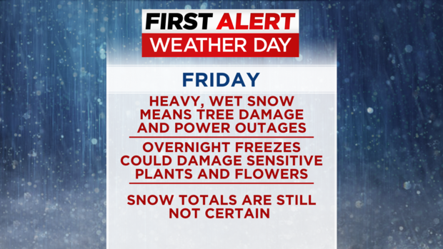
In addition to the wet weather, temperatures will be unusually cold both Friday and Saturday. High temperatures will only be in the 30s and 40s and overnight lows will be at least a degree or two below freezing. The coldest temperatures will occur Sunday morning when the Denver area could experience a hard freeze. Sprinkler systems should be shut off this weekend (but don't need to be drained) and sensitive or newly planned plants and flowers should be protected.
Saturday night and Sunday will be much drier overall but there is still a chance for showers as unsettled weather remains over Colorado well into next week.