Denver Weather: Friday's High Fire Danger Is Being Called 'Extremely Dangerous'
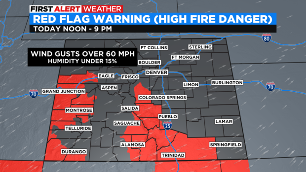
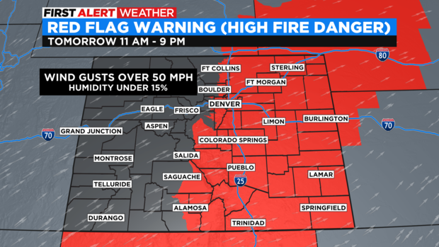
DENVER (CBS4) - Fire danger will be elevated again on Thursday but not has critical as it will be on Friday. Denver and most of Colorado outside of the mountains is already under a Red Flag Warning starting at 11 a.m. Friday.
Red Flag Warnings for high fire danger on Thursday are limited to southern and western Colorado including in Monte Vista where a fire destroyed 10 buildings on Wednesday. The warnings go from 12 p.m. until 9 p.m. Thursday. The combination of wind gusts over 60 mph together with very low relative humidity, dry soil, and above normal temperatures will help drive the danger for additional wildfires.
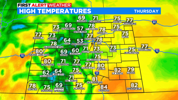
In the Denver metro area, it will be breezy at times on Thursday but wind gusts should remain under 30 mph and therefore the fire danger is lower compared to the southern and western regions of the state. It will also be noticeably warmer on Thursday with afternoon temperatures in the upper 70s around Denver, Boulder, and Fort Collins.
Temperatures should reach at least 80 degrees in Denver on Friday and will combine with southerly wind gusts over 50 mph and relative humidity under 15%. This combination will create what the Boulder office of the National Weather Service called a "potentially high impact weather event across northeast Colorado on Friday including extremely dangerous fire weather conditions".
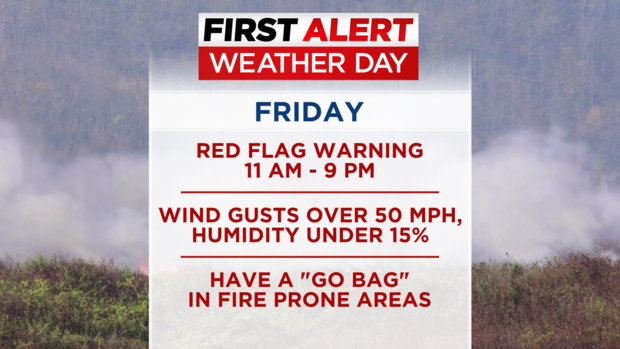
To highlight the concern, a Red Flag Warning has already been issued for Friday which is unusual. Typically Red Flag Warnings are not issued before the day they go into effect. The warning has been issued from 11 a.m. until 9 p.m. and includes Denver and the entire I-25 urban corridor in Colorado. All of the Eastern Plains are also included where blowing dust and hazardous travel conditions are expected along I-70 and I-76 and other local highways east of the Denver metro area Friday afternoon.
Any spark from any source on Friday could carry fire very quickly. Fire officials are urging residents who live in fire prone areas to have a "go bag" ready with important documents, medications, valuables, etc. in the event of an evacuation notice. Residents are also strongly encouraged to sign up for emergency notifications at https://dhsem.colorado.gov/emergencyalert.
Needless to say, the CBS4 weather team has declared Friday a First Alert Weather Day due to fire danger.
After the Marshall Fire impacted urban areas in Superior and Louisville last December, the definition of "fire prone area" is not as clear as it once was in Colorado. Therefore everyone outside of the higher mountains (everywhere without snow on the ground) needs to be weather aware on Friday.
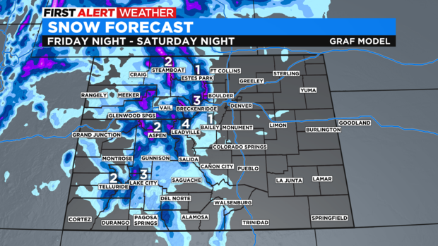
A strong cold front will arrive Friday night which will end high fire danger for the weekend. Temperatures will be about 25 degrees cooler in the Denver metro area but unfortunately any moisture along the Front Range is expected to be very limited. Most moisture this weekend will be found in the mountains where 2-4 inches of snow is expected for many mountain towns. The higher peaks and mountain passes could easily get more than 6 inches.
With the chance for rain only 20-30% in metro Denver this weekend, fire danger is likely to return next week as warm and dry conditions return.