First Alert Weather Day: For 8th Week Straight, Snow Is Impacting Colorado's Front Range
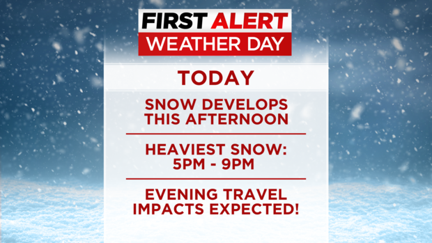
DENVER (CBS4) - Snowy, slick, and very slow travel will plague the evening commute on Wednesday prompting a First Alert Weather Day for Colorado's Front Range. A Winter Storm Warning starts at 2 p.m. for the metro area and continues through 5 a.m. Thursday.
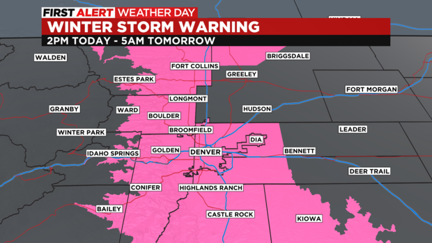
The heaviest snow in the Denver metro area should fall between 5 p.m. and 9 p.m. and will then gradually end through the late night hours. During the evening, snowfall rates could reach 1 inch per hour especially in the foothills of Jefferson, Boulder, and Larimer Counties where the highest snow totals are expected.
Areas such as Conifer, Evergreen, Black Hawk/Central City, Nederland, and Estes Park should see 6 to 12 inches of snow. Farther east, locations between the base of the foothills and I-25 including Lakewood, Littleton, Arvada, and Longmont should see 4 to 8 inches. And then mot of Northern Colorado including Fort Collins and Loveland as well as the Denver metro area east of I-25 including Aurora, Brighton, and Commerce City should see 3 to 6 inches of snow.
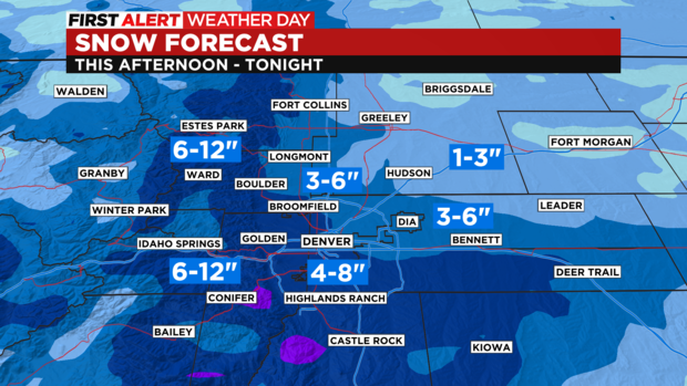
Most of the Eastern Plains will be lucky to see 1-2 inches and it's the same story for lower elevations on the Western Slope.
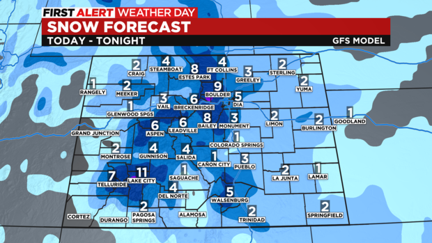
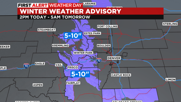
In between, the mountains will get 4 to 8 inches on average with higher amounts east of Vail Pass including I-70 between Georgetown and Copper Mountain. That stretch is under a Winter Weather Advisory from 2 p.m. Wednesday until 5 a.m. Thursday for 5 to 10 inches of snow. The Winter Park area and the Rocky Mountain National Park region are also part of the advisory.
The snow will end long before the Thursday morning commute but many roads will continue to be snowpacked and icy. Temperatures will also be cold on Thursday with morning lows in the single digits and teens and afternoon highs only in the 30s.
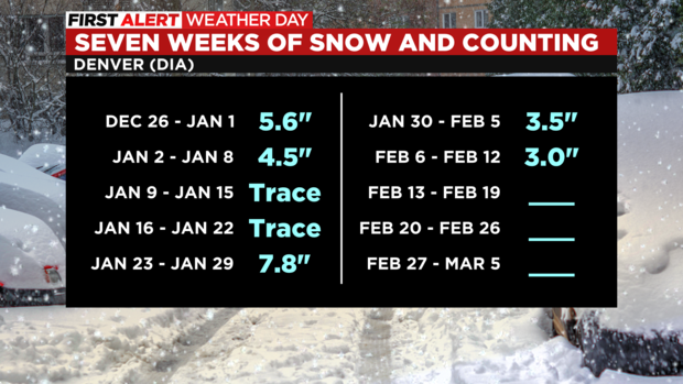
Once snow is officially observed at DIA on Wednesday, it will mark the eighth consecutive week with snow in the city. Long range models suggest Denver could go at least 10 weeks straight with more snow coming next week and into the first week of March.
Gradual warming will occur for Friday, Saturday, and Sunday before another winter storm approaches next week. More snow is likely in Colorado for multiple days starting Monday. We'll keep you posted!