Snow Comes A Day Late For Boulder County, It's Arriving Along With Frigid Temperatures
DENVER (CBS4) - Regardless of what sparked the Marshall fire on Thursday, the combination of fierce wind and drought caused flames to bring about wildfire destruction never seen before in the metro area. Quickly changing weather on Friday will put out the final hotspots with several inches of snow and bitterly cold temperatures on the way.
The winter storm responsible for the change will bring snow to the mountains throughout the day on Friday while most of the snow for Denver and the Front Range waits until at least Friday afternoon. Then snow will become likely Friday evening and through the late night hours with at least 2-4 inches of snow accumulation for most neighborhoods along the urban corridor including Superior and Louisville by daybreak on Saturday. Then another 1-2 inches of snow is likely Saturday morning before dry but very cold weather dominates for Saturday afternoon and Saturday night.
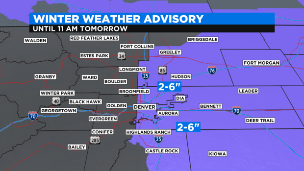
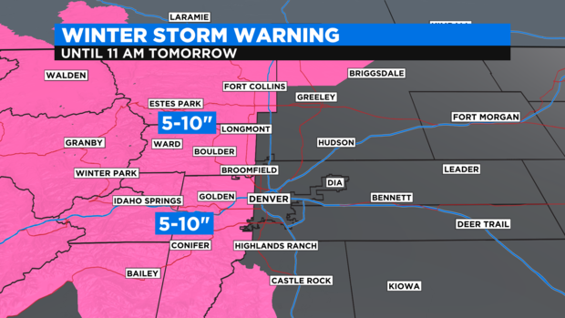
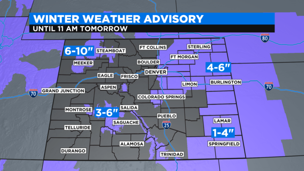
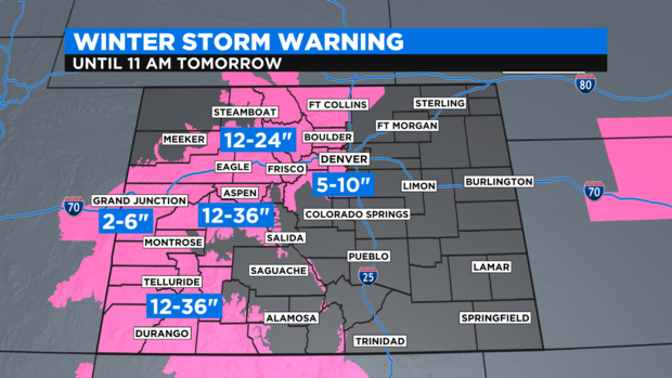
In terms of the official warnings and advisories, the Front Range is spilt between areas along and east of I-25 and then areas west of I-25 where the heaviest accumulation should fall.
For communities mostly east of I-25 including Denver, Aurora, Commerce City, Brighton, and Greeley, there is a Winter Weather Advisory from 11 a.m. Friday until 11 a.m. on Saturday for total snowfall between 2 and 6 inches.
Areas west of I-25 including Littleton, Lakewood, Arvada, Golden, Boulder, Longmont, Loveland, and Fort Collins, there is a Winter Storm Warning from 11 a.m. Friday until 11 a.m. on Saturday for total snowfall between 5 and 10 inches. The higher amounts should mostly be above 6,000 feet in the foothills of Jefferson, Boulder, and Larimer Counties including Conifer, Evergreen, Nederland, Ward, Estes Park, and Red Feather Lakes.
On the Eastern Plains, there is a Winter Weather Advisory for 4 to 6 inches of snow across most of northeast Colorado including Fort Morgan, Sterling, Akron, and Burlington. Farther south, amounts should be less around Lamar and Springfield.
For the Colorado mountains and the Western Slope, there is a Winter Storm Warning for virtually every area with the highest accumulation expected south of I-70. For the I-70 mountain corridor above Georgetown, 12 to 24 inches of snow is expected to about Avon and then 2 to 6 inches is expected west of Avon into eastern Utah.
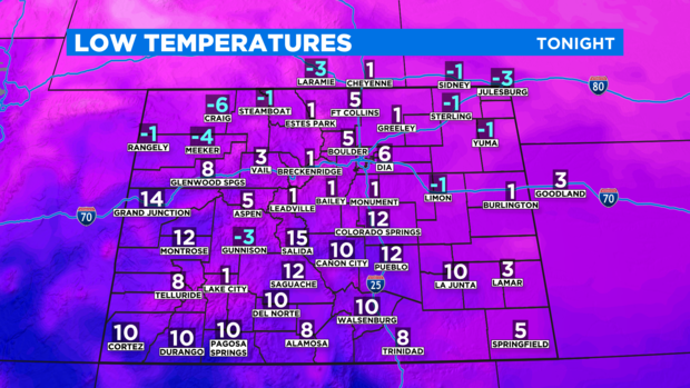
In terms of temperatures, the new year will start with the coldest night of the season so far in much of Colorado. In the Denver metro area, low temperatures will be in the single digits Friday night and wind chill values will drop below zero at times.
If you plan to be outside for New Year's Eve, be sure to be prepared for extremely cold temperatures along with snow and occasional wind gusts up to 25 mph in the metro area.