Colorado Weather: The Next Winter Storm Is A Different Animal, Denver Will Actually Get Snow
DENVER (CBS4) - Multiple storms in recent weeks have brought piles of snow to Colorado's mountains but no significant moisture to Denver and the Front Range. That should finally change with a new storm taking aim at the state.
The large storm was in California Wednesday morning and will start to spread heavier snow across the mountains late Wednesday night into Thursday morning. Before then, snow in the mountains will be light with only minor accumulation.
A Winter Storm Watch has been posted for most mountain areas in Colorado from Wednesday night through Friday night.
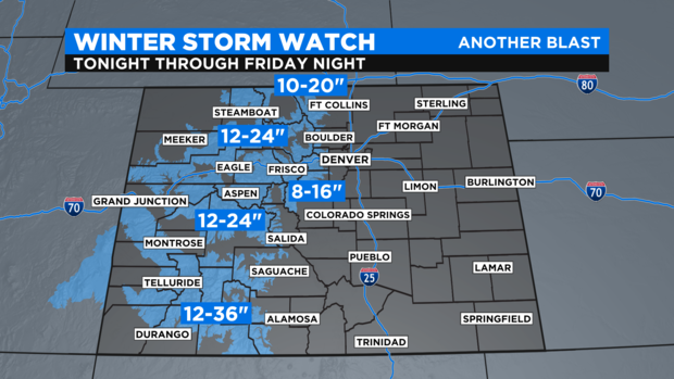
The heaviest snow will be in the San Juan Mountains where up to 3 feet of snow is possible for ski areas like Wolf Creek, Purgatory, and Telluride. Farther north, up to 2 feet is snow is in the forecast for ski areas like Crested Butte, Vail, Beaver Creek, Aspen, and Steamboat. For the mountains of Summit County and the I-70 corridor between Georgetown and Copper Mountain, total snowfall from Wednesday night through Friday night will range from 8 to 16 inches including for ski areas like Loveland, Keystone, Breckenridge, and Arapahoe Basin.
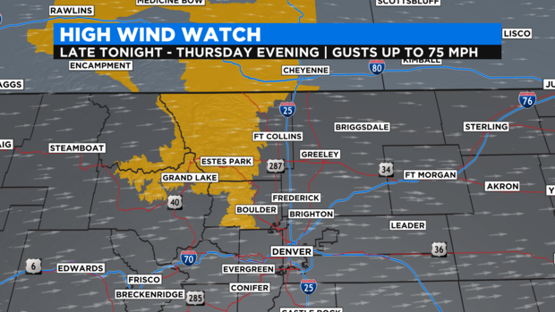
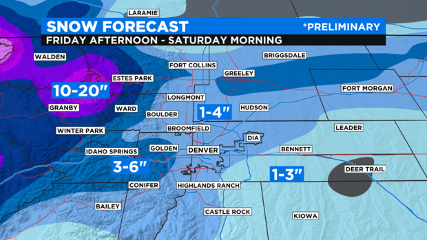
The Rocky Mountain National Park region is also under a Winter Storm Watch for 10 to 20 inches of snow along with with some very intense wind from late Wednesday night through Thursday evening. Wind gusts in areas like Red Feather Lakes, Estes Park, Grand Lake, Granby, Nederland, and Ward could reach hurricane strength with 75 mph gusts.
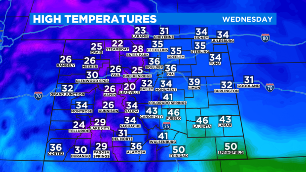
For Denver and the Front Range, it stays dry on Wednesday and Thursday before snow finally arrives starting in the afternoon on Friday. Temperatures will be quite chilly again on Wednesday with highs in the 30s around Denver, Boulder, and Fort Collins. That's below normal for late December.
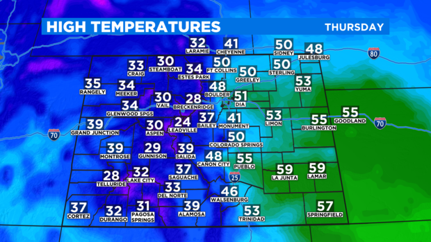
Then somewhat warmer weather will return for Thursday ahead of a strong cold front on Friday.
Once the front passes over the metro area around midday on Friday, a few snow showers may initially develop in the afternoon. Then more widespread snow should follow Friday night into very early Saturday morning. At this time, total snowfall around Denver, Boulder, and Fort Collins is expected to range from 1 to 4 inches with higher amounts in the foothills.
Certainly the most significant snow will stay in the mountains for New Year's Eve but it will also be quite cold and windy at times in the metro area for NYE celebrations. The overnight low on Friday night should reach the single digits in Denver.