Denver Weather: Another Storm Will Miss The Front Range, Snow Guaranteed In The Mountains
DENVER (CBS4) - Just like every recent storm to hit Colorado, the storm arriving Tuesday night will bring snow to the high country and very little if anything to Denver and the Front Range.
This is entirely because of the trajectory of the storm. Usually by November the storm track across the country has moved far enough south to allow storms to track closer to Colorado's border with New Mexico than Wyoming. Storms that track across southern Colorado have a much better chance of bringing snow to Denver and the Front Range compared to storms farther north.
Unfortunately, the storm track will be too far north this week to bring anything other than spotty light rain and snow to the metro area on Thursday and Thursday night.
It has now been over 200 days since the last measurable snow in Denver which is an usually long period time with no snow in the Mile High City. It has also been more than three days since the average first snow (October 18) and the record for the latest first snow on record (November 21) is now just 12 days away.
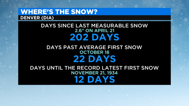
With no accumulating snow expected this week or even next week, it is entirely possible Denver could set a new record this year for the latest first snow. And that is ironic considering the first snow last year arrived on September 8 which was a tie for the second earliest snow on record.
Meanwhile, the mountains will do well with snow starting Tuesday night. A Winter Weather Advisory has been issued for the northwest mountains including Rabbit Ears Pass and The Flat Tops region for at least 4-8 inches of snow Tuesday night and Wednesday. The advisory includes the mountains surrounding Steamboat Springs including the ski area which is set to open on November 20.
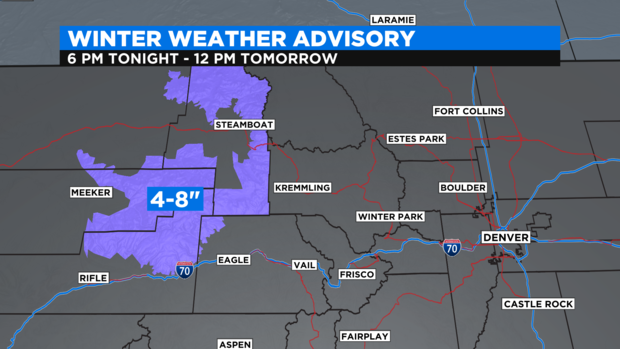
Elsewhere in the high country, most areas above 9,000 feet will get 2-5 inches of snow from Tuesday night through Thursday night. Mountain passes like Berthoud, Loveland, and Vail Pass should get more. Travelers should be prepared for slick roads and slow traffic on Wednesday and Thursday.
For Denver and the Front Range, there is a 10-20% chance for a very quick rain or snow shower on Thursday and Thursday night and nothing more.