Under New Map, North Metro Area Could Be Site Of 8th Congressional District
(CBS4) - A preliminary map of Colorado's new eight congressional districts is now out. The state's population jumped nearly 15% since the last census, giving us an additional seat in Congress. The map released Wednesday is a starting point for where the lines will fall.
It was drawn by non-partisan staff in the legislature. The final maps for both the congressional districts and state legislative districts will be drawn by independent commissions. Voters passed ballot measures in 2018 that scrapped the traditional redistricting process involving backroom deals by lawmakers.
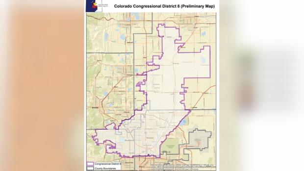
Under the draft map, the new 8th congressional district is in the north metro area, which has seen the biggest population growth. It includes Arvada, Broomfield, Thornton, Westminster, and part of Weld county. While it leans Democrat, it will be a competitive seat.
Congressman Ed Perlmutter's seat is also more competitive now, encompassing Castle Rock, while Rep. Lauren Boebert's district includes part of Boulder County, although it still leans Republican.
Jeremiah Barry, a legislative staff member who helped draw the map, says, "Given the population distribution in Colorado it's very difficult to draw more competitive districts."
Competitiveness is only one consideration. It's more important, he says, the districts be equal in population.
"No district is more than one person off of the ideal district size," Barry said.
Districts not only must be equal in number, but the lines must be contiguous and as compact as possible to avoid gerrymandering or drawing lines to benefit one party over another.
Legislative staff member Jessika Shipley explained how keeping communities of interest together is more important than keeping them competitive.
"Keeping Boulder and Fort Collins together was a big one that we heard because of the shared university culture," she said.
The map also largely keeps mountain communities that share tourism interests together and agricultural rich eastern plains communities.
"We're going to be in a place where not being 100% of people being happy about the plan," said Carly Hare, who chairs the independent congressional redistricting committee.
But unhappy Coloradans will be happy to know this isn't the final plan and Barry says there will be ample opportunity for people to weigh in.
"There could be hundreds of maps the commission is asked to review."
The congressional and legislative commissions are required to hold 21 public meetings across the state so we can see their draft maps and provide input on where the lines should be. The preliminary state legislative map is due by the end of the month.
Detailed block-level census data is expected in August and will also reshape the maps. They need to be submitted to the State Supreme Court by November.