Denver Weather: Warm For Father's Day Weekend But Far From Record Heat
DENVER (CBS4) - After unpresented heat this week, a summer cold front will drop temperatures about 10 degrees for the weekend. It will be a welcomed change after three days with triple digits along the Front Range.
Denver experienced the earliest occurrence of consecutive days with temperatures reaching at least 100 degrees. Denver's official high temperature on Tuesday was 101, followed by 100 on both Wednesday and Thursday. All three high temperatures set new records for the dates.
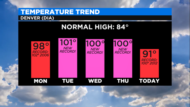
Denver also set a new record for the "warmest minimum" temperature on Thursday since the temperature never dropped below 68 degrees on June 17th. In other words, it's never stayed so warm on this date.
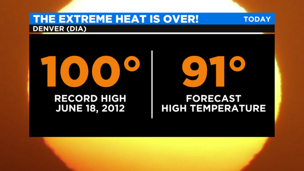
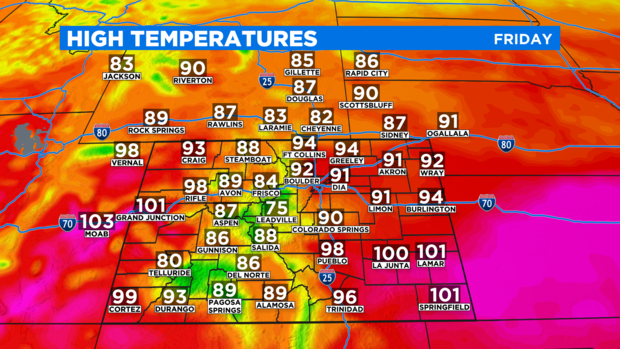
Looking ahead to Friday, the record high temperature is 100 degrees from June 18, 2012 which is 100% safe. There is no chance of a record on Friday for the first time since last weekend.
Despite the drop in temperatures, it will still be quite warm with the Front Range staying at least 5 degrees above normal for the third week in June. A few areas in southeast Colorado and on the far Western Slope near Utah may still reach at least 100 degrees again. It should be the sixth consecutive day reaching at least 100 degrees in Grand Junction and the fifth day in a row for Lamar.
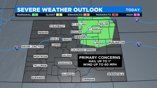
The same cold front responsible for the somewhat cooler weather will also help bring a somewhat better chance for afternoon and/or evening thunderstorms to northeast Colorado on Friday. The chance for thunderstorms in the Denver metro area is only 20%, but if a storm manages to develop, it could produce hail and very gusty winds. The threat for severe weather is considered "marginal" which is at the lowest end of the severe weather threat scale.
For the weekend, the chance for afternoon thunderstorms will increase on Saturday particularly in the mountains. And a handful of storms that originated in the mountains will likely reach the Front Range mainly after 3 p.m. Saturday. And just like on Friday, a few of these storms could be severe with wind and hail. The chance for late day thunderstorms is smaller on Sunday.
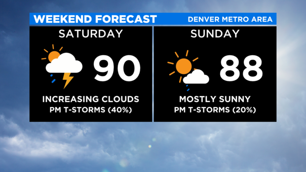
Sunday night a stronger cold front will pass over lower elevations east of the mountains including the metro area. This front is expected to bring the coolest weather the Front Range has experienced since Memorial Day weekend with highs only in the 60s and lower 70s on Monday.