Storms Keep Missing Western Colorado Where Extreme To Exceptional Drought Remains
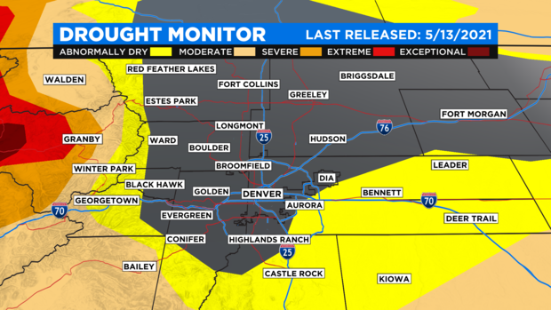
DENVER (CBS4) - The weekly drought monitor released Thursday showed more improvement in eastern Colorado thanks to a very active storm track in recent weeks. Parts of the Front Range are now drought free, including most of metro Denver.
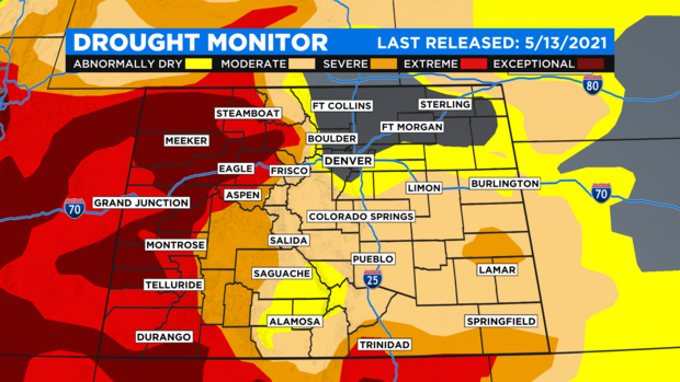
But it's a much different story on Colorado's western slope where conditions are bad. Recent storms have produced scattered showers but nothing as widespread and long-lasting as what we've seen on the Front Range.
Since January 1 the city of Grand Junction is running over an inch behind normal on precipitation. Although that doesn't sound like much it is a lot for an area that has an extremely dry climate. The year 2020 only produced 5.11 inches of precipitation in Grand Junction which was over four inches below normal.
Here's a breakdown of drought in Colorado for the map released on Thursday, May 13.
D0 - Abnormally Dry (92.2% of Colorado)
- hay production decreases, rangeland is dry
- irrigation begins sooner
D1 - Moderate Drought (79.9% of Colorado)
- dryland crops suffer
- rangeland growth is stunted, very little hay is available
- wildfires increase
D2 - Severe Drought (51.9% of Colorado)
- farmers reduce planting, producers sell cattle
- fire season is extended
- snowpack is low, surface water levels are low, river flow is reduced
D3 - Extreme Drought (31% of Colorado)
- pasture conditions worsen
- large fires develop
- reservoirs are extremely low, mandatory water restrictions in implemented, water temperatures increase
D4 - Exceptional Drought (16.4% of Colorado)
- dust storms and topsoil removal are widespread
- agricultural and recreational economic losses are large
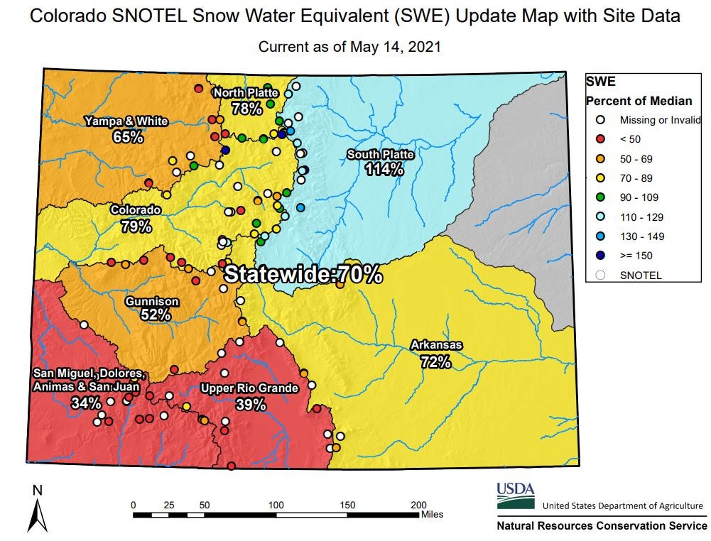
Snowpack has melted fast this year on the western slope. Very dry soils are soaking up a lot of the snowmelt and that is resulting in reduced river flows.
The region is preparing for the possibility of large wildfires once again this summer. Western Colorado needs an active monsoon to materialize this year, which is a seasonal shift in the surface wind pattern. That wind shift transports warm, humid air from Mexico into the desert southwest which sets the stage for slow-moving afternoon showers and thunderstorms.
Monsoon season officially starts in the middle of June and lasts through September. Colorado typically sees the most benefit from late July through the middle of August. One downside to monsoon thunderstorms is the amount of lightning they produce which can spark wildfires. They can also unleash deadly flash floods, especially around and over recent burn scars.