Denver Weather: Arctic Cold Front Guarantees Snow, Tough Evening Commute
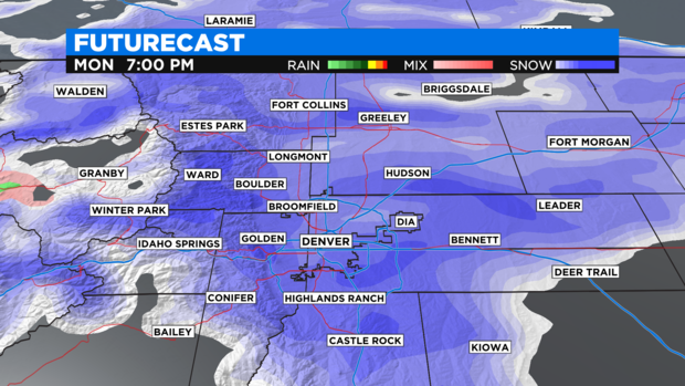
DENVER (CBS4) - An unusual April arctic cold front blasted south along the Front Range Monday morning. Snow will develop in the afternoon and there is a good chance for heavy snow and difficult travel in the evening.
The storm will hit hard and fast and will depart just as quickly. Most areas will not see snow longer than 6 to 9 hours.
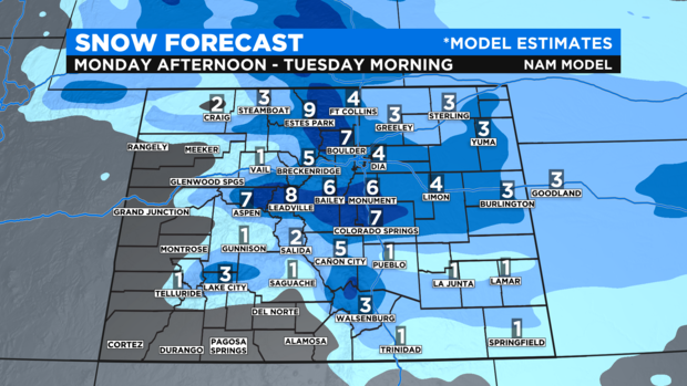
The heaviest snow and worse conditions will be over the western suburbs of Denver and into the foothills and mountains of Boulder and Larimer Counties. These locations have been placed under a Winter Storm Warning starting as early as 12 p.m. Monday and continuing through 3 a.m. Tuesday. Lower elevations within the warning including Boulder, Golden, Longmont, Arvada, and Lakewood can expect 5-8 inches of snow while areas above about 6,500 feet including Nederland, Red Feather Lakes, and Rocky Mountain National Park can expect 6 to 14 inches.
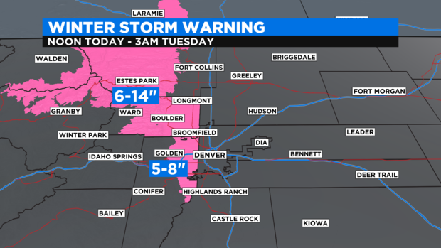
All other areas around Denver, Fort Collins, and Greeley are under a Winter Weather Advisory also through 3 a.m. Tuesday for 3 to 6 inches of snow. The far eastern side of the urban corridor could get less.
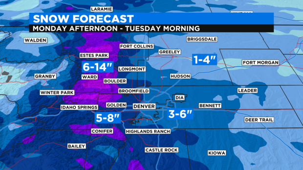
The heaviest snow should fall during the early evening hours between 5 p.m. and 9 p.m. There is no chance of the snow missing any part of the Front Range. It will snow everywhere and travel could be difficult with very limited visibility.
Elsewhere in Colorado, most areas in the state will get at least an inch or two of accumulation will the exception being the Western Slope where it will stay mainly dry.
Because this storm will contain arctic air, the snow will be different compared to recent storms. Instead of heavy and wet, it will be relatively dry and fluffy. The type of snow far more common in December or January and not in April.
And speaking of cold, temperatures are expected to drop into the teens around Denver, Boulder, and Fort Collins Tuesday morning. The record low temperature for Denver on Tuesday is 13 degrees set on April 20, 1966. If the snow stops early enough, the wind calms down soon enough, and skies clear, the record could be in jeopardy.
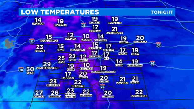
Regardless of the record, it will be a hard freezing Tuesday morning and likely again Wednesday and Thursday morning causing negative effects on all emerging spring vegetation.
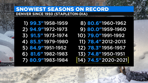
As of Monday morning, Denver has officially received 74.5 inches of snow this season as measured at the airport. That's enough to rank 14th on the list of snowiest seasons since Denver started measuring snow at the airport in 1950. This storm could easily move the 2020-2021 season into the Top 10.
Looking ahead this week, snow is likely to return on Wednesday although any accumulation should be limited. More cooler than usual and unsettled weather will continue for Thursday and Friday before drier and warmer weather finally returns for the weekend.