Denver Weather: Two Really Good Chances For Spring Snow This Week
DENVER (CBS4) - An unusual storm system set to crawl across Colorado will bring cloudy skies, chilly temperatures and numerous chances for rain and snow over at least 5 days.
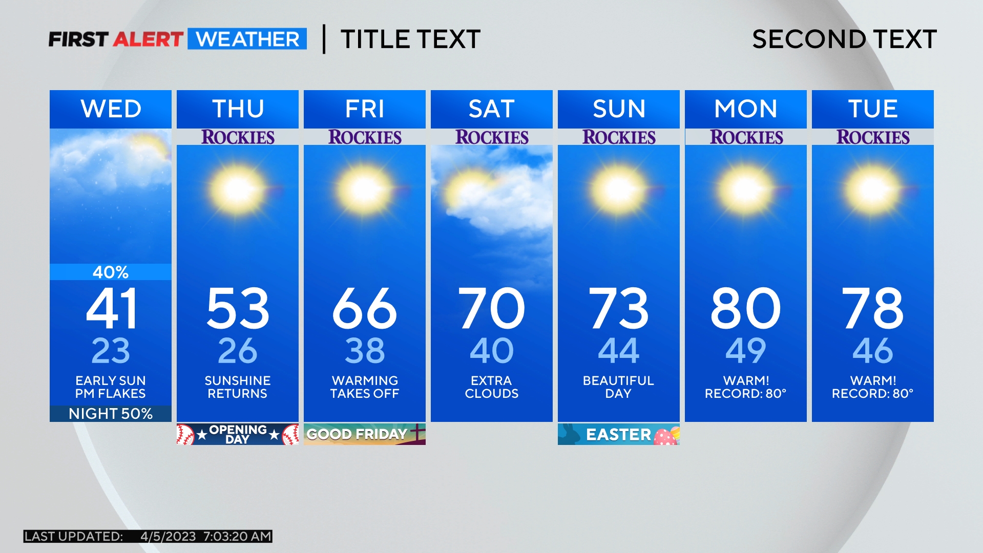
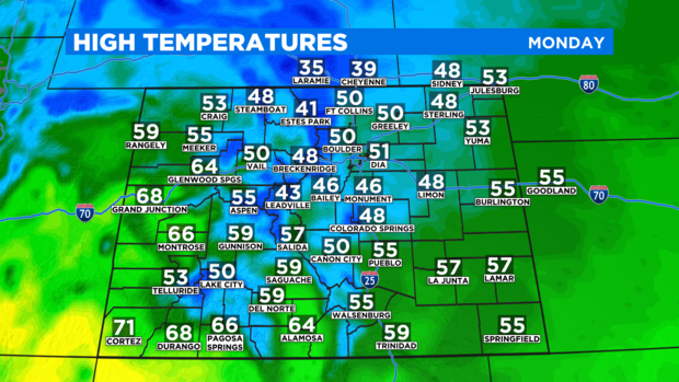
The system will start to influence Colorado's weather Monday night. Until then, most of the state will remain dry and mostly clear through at least Monday evening. Despite the sunshine on Monday, temperatures will continue a cooling trend that started on Sunday. The Denver, Boulder and Fort Collins areas will be lucky to reach 50 degrees Monday afternoon.
Even cooler weather arrives Tuesday with high temperatures in the Denver metro area expected to stay in the 40s through at least Saturday.
In terms of moisture, there is a chance for snow in the mountains Monday night followed by a chance for light snow on the west side of the Denver metro area (west of I-25) Tuesday morning. No accumulation is expected outside of the mountains through early Tuesday.
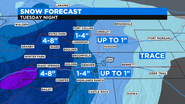
Then a much better chance for snow across the entire Denver metro area will develop mainly after 6 p.m. Tuesday. It should eventually snow for everyone along the urban corridor Tuesday night into early Wednesday morning with most of the snow ending before sunrise. Accumulation will be relatively minor with just 1-2 inches of snow mainly on the grass, rooftops, and vehicles for most areas. Higher amounts are possible for areas near the base of the foothills including Ken Caryl, Golden, and Boulder where up to 4 inches is possible. The foothills themselves as well as the mountains should expect 4 to 8 inches including slushy roads for the Wednesday morning commute.
Then from late Wednesday morning through Thursday afternoon there is a chance for light rain or snow at virtually anytime but precipitation is expected to be limited at this time.
The next good chance for snow including in the Denver metro area will develop by Thursday night and should continue through much of Friday. There is no agreement among the various weather models on how much snow will accumulate but it seems very likely we'll have at least 2-4 inches around Denver, Boulder, and Fort Collins with the potential for more.
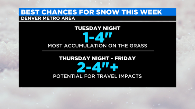
Thursday night and Friday morning is also when there is a great potential for travel impacts in the Denver metro area including slushy roads.
Overall, there is the potential for more than 1 inch of liquid precipitation (including melted snow) this week which is great news considering the current drought and snowpack situation in Colorado.
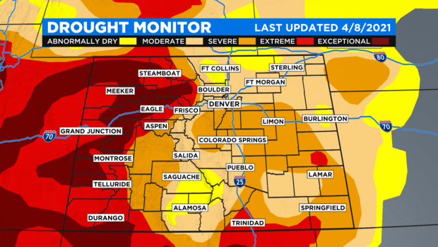
When it comes to drought, 92% of the state continues to experience at least moderate drought.
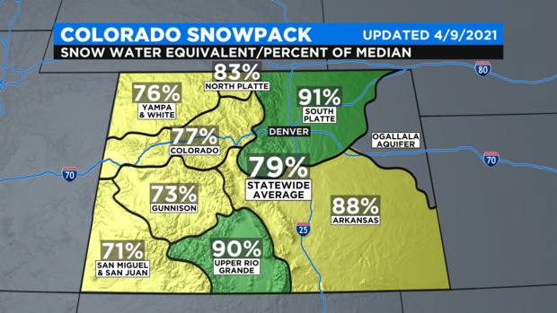
And statewide snowpack is at 79% of average for the second week in April which is typically when snowpack reaches it peak in Colorado.
The combination of significant moisture and much colder than normal temperatures could have the triple benefit of slowing the spring snowmelt, increasing the snowpack for at least some river basins, and possibly improving drought conditions particularly for the northeast quadrant of the state.
The next chance in the weather pattern should arrive early next week with the potential for sunny skies and warmer temperatures on Monday (April 19).