Denver Weather: Dramatic Change Ahead With 70 Degrees Monday Before Snow Monday Night
DENVER (CBS4) - Very gusty westerly winds over the higher peaks and mountain passes west of Denver will trickle into the metro area on Monday allowing temperatures to soar into the lower 70s. Then the wind abruptly shift to the north Monday evening and snow is likely Monday night.
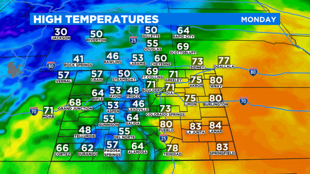
The downsloping effect caused by the westerly wind along the Front Range could bring the warmest air of the year so far. The warmest temperature Denver has experienced 2021 was 70 degrees on March 7. The city should reach at least 71 degrees Monday afternoon.
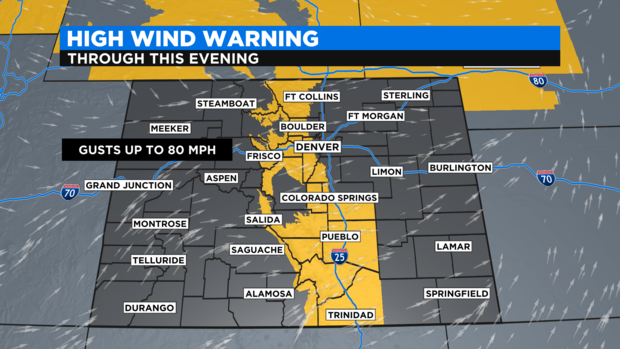
Meanwhile, the wind responsible for the big warmup could gust up to 45 mph east of I-25 and up to 60 mph west of I-25.
Even stronger wind gusts are expected to continue in the foothills and mountains east of Vail Pass. A High Wind Warning is in effect through Monday evening for gusts up to 80 mph over the higher peaks and mountain passes like Loveland, Berthoud, and the I-70 approaches to the Eisenhower Tunnel. A warning is also in effect for the I-25 corridor south of Monument Hill through 6 p.m. Monday.
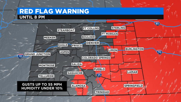
In southeast Colorado, the gusty wind and low humidity will contribute to high fire danger. A Red Flag Warning is effect through 8 p.m. Monday for cities like Fort Morgan, Sterling, Limon, Burlington, Pueblo, La Junta, Lamar, Walsenburg and Springfield.
A cold front that was in western Wyoming early Monday morning will reach Denver and the Front Range in the evening hours. Once the front passes, winds will immediately shift to the northwest and temperatures will quickly drop. The metro area will should be below freezing by midnight. Snow should also start by around midnight but will not last long and therefore accumulation should be relatively light.
Most neighborhoods around Denver and Boulder should get no more than and inch or two of snow mainly on the grass. Locations in the lower foothills (up to about 7,500 feet) could easily get up to 3 inches of snow while areas above 7,500 feet will likely see 3-6 inches of snow.
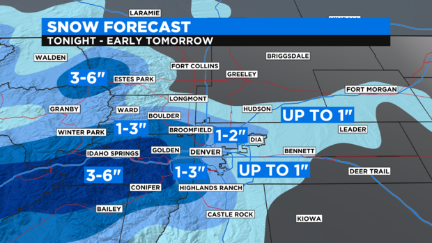
Most of the accumulation will end by early Tuesday morning but additional snow possible into the early afternoon. It's possible the Palmer Divide in Douglas and Elbert Counties could still have a few snow showers as late as 5 p.m.
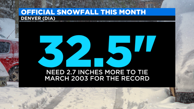
As of Monday morning, Denver has officially received 32.5 inches of snow this month which is a tie with March 1944 for the second snowiest March on record. In first place is March 2003 when 35.2 inches was recorded. So it would take just 2.7 inches of snow Monday night for March 2021 to tie for the snowiest March ever recorded.
Skies will clear Tuesday night allowing for a return of clear skies and chilly temperatures Wednesday morning. No additional storms are expected to come anywhere close to Colorado for at least a week and perhaps much longer. It will be a long stretch of clear skies and warmer than normal temperatures starting later this week.