Denver Weather: Colorado Digs Out Monday Before Another Storm Approaches Tuesday
DENVER (CBS4) - The historic storm that brought Denver's biggest snow in 18 years will continue moving away from Colorado on Monday. A much smaller storm is taking aim at the state for Tuesday with the the most impactful weather staying in the southern half of the state.
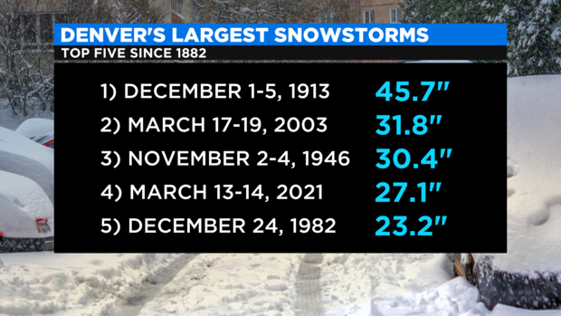
The weekend storm officially brought 27.1 inches of snow to Denver as measured at the airport (DIA).
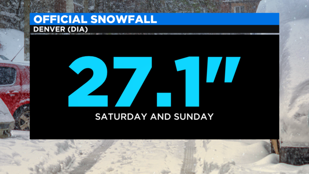
That was the biggest snow total in the city since March 17-19, 2003 when the airport measured almost 32 inches. The weekend total was also enough to displace the Christmas Eve blizzard of 1982 for 4th place on the list of Denver's largest snowstorms since records started nearly 140 years ago.
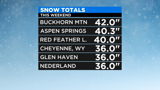
The highest snow total measured in the state over the weekend was 42 inches at Buckhorn Mountain which is just above Horsetooth Reservoir and Lory State Park west of Fort Collins. Many other locations in the foothills of Jefferson, Boulder, and Larimer Counties measured at least 3 feet of snow. There was also 36 inches of snow in Cheyenne which was the most snow ever recorded in the history of Wyoming's capital city.
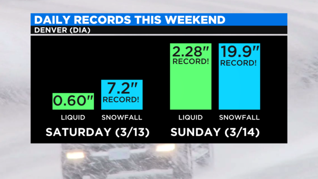
Other daily records were also broken in Denver including the most snow ever measured in the city on March 13 and March 14 and the previous record for liquid precipitation was shattered for March 14 with 2.28". Over the both days this weekend, a total of 2.88 inches of liquid fell which is about 20% of our normal annual precipitation in Denver. And of course that's why the snow was so heavy and wet!
Looking ahead to Tuesday, a fast moving storm will trek across the southern half of Colorado starting the morning. Snow is likely in the San Juan Mountain in southwest Colorado by Tuesday afternoon followed by an excellent chance for snow along the I-25 corridor south of Pueblo by Tuesday evening.
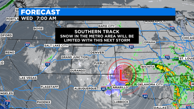
Because the storm will stay south, snow in the Denver metro area is expected to be limited. It is possible up to 1 inch of accumulation could develop mainly after sunset on Tuesday.
Then drier weather will dominate most of Colorado for the end of this week but temperatures will be slow to warmup particularly with so much snow on the ground.