Denver Weather: Major Colorado Snowstorm Moves In, Will Not Stop Dropping Moisture For 36 Hours
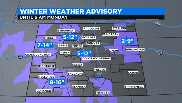
DENVER (CBS4) - The delayed storm that moved into to Colorado late Saturday morning still promises widespread snow. The Denver metro area's heaviest snow will wait until the afternoon and total accumulation is still expected to be enough to cause significant travel issues. The entire Colorado Front Range urban corridor between Colorado Springs and Cheyenne, Wyoming, are under a Winter Storm Warning through 6 a.m. Monday.
A total of 12 to 24 inches of accumulation is expected for most of the Denver metro area. The Fort Collins and Boulder areas could get up to 30 inches while the foothills and mountains east of Vail Pass are expecting 24 to 48 inches.

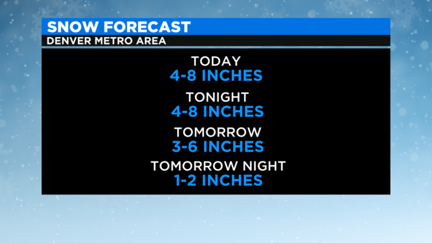
Breaking down the metro area snow by time period, the snow that accumulates from late morning through early evening should total 4 to 8 inches depending on how fast accumulation starts.
Then another 4 to 8 inches is expected Saturday night followed by 3 to 6 inches on Sunday. Then another 1-2 inches Sunday night into early Monday morning.
Elsewhere around the state, Winter Weather Advisories continues for portions of the Eastern Plains, the Western Slope, and mountain areas that are not included in the Winter Storm Warning.
After the snow ends early Monday morning, most of the state will be dry until another storm arrives on Tuesday.
RELATED: Snowfall And Liquid Precipitation Records Possible In Denver This Weekend | Colorado Is Known For Heavy March Snow, One Storm Ended Record Drought In 2003
That storm will likely bring more accumulating snowfall in the metro area.