Denver Weather: Frigid Colorado Weekend Ahead With Snow Likely In Metro Area
DENVER (CBS4) - A surge of even colder arctic air will reach Denver and Colorado's Front Range on Friday and will stay for the weekend. Sunday could be the coldest Valentine's Day on record in Denver along with a good chance for snow Saturday night into Sunday.
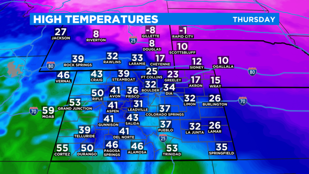
Prior to the extremely cold air arriving on Friday, Thursday will be another cold day with highs in the 20s and 30s for all lower elevations east of the mountains including the Denver metro area. The cold air is shallow so the foothills, Palmer Divide, and many mountain towns will be somewhat warmer with highs mainly in the 40s.
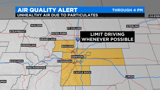
The temperature inversion responsible for the large discrepancy in temperatures will also cause more clouds, fog, and flurries on Thursday especially in the morning. The inversion will also trap particulate matter (pollution) near the ground so the state has issued another Air Quality Alert for the Denver metro area through 4 p.m. Thursday. All residents are encouraged to limit driving non-EV vehicles whenever possible to help reduce the amount of pollution in the air.
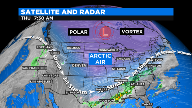
The jet stream which is a highway of fast moving wind in the upper levels of the atmosphere will shift even farther south and west of Colorado through the weekend. And since the jet stream divides warm air from cold air, the shift south and west means even colder air will be able to reach the state.
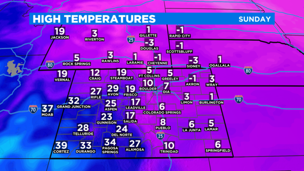
Sunday will be coldest day of the holiday weekend with highs mainly in the single digits for just about everyone east of the Continental Divide.
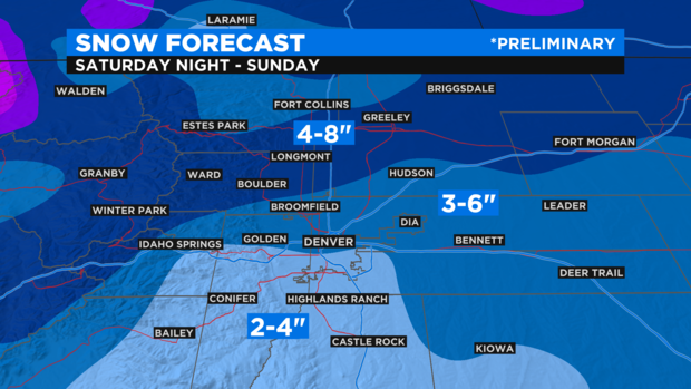
There is also a good chance for snow along the Front Range this weekend mainly Saturday night into Sunday. Snow is also possible on Friday and Saturday but any accumulation should be minor through Saturday afternoon.
The preliminary snow forecast is for at least a few inches of accumulation for most of us along the urban corridor. The highest snow amounts may end up on the north side of town. Below is a preliminary snow forecast map that will likely need to be adjusted in the coming days.
Warmer weather will finally start returning by late next week. Until then, we stay cold!