Colorado Weather: Summer Snow On The Way Tonight
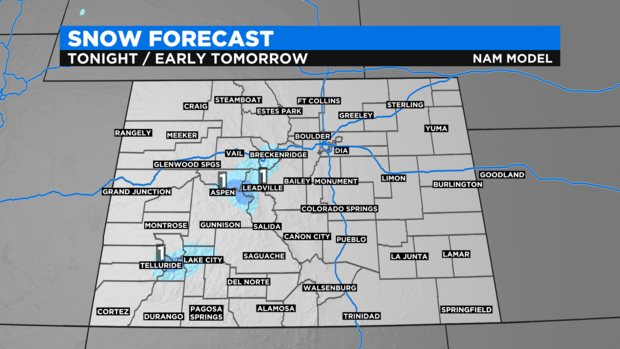
DENVER (CBS4) - A summer cold front followed by a vigorous upper-level storm system should produce summer snow over Colorado's higher mountains Monday night. In many cases, it could be the first accumulating snow of the season.
The storm system will move from northern Idaho to southwest Wyoming during the day on Monday and then pass directly over Colorado Monday night. The best chance for snow will be after 10 p.m. above 10,000 feet in the mountains along and south Interstate 70. Any accumulation will be minor and generally range from a dusting to 1 inch.
Snow in late August is not necessarily uncommon although many years the first snow waits until September in the Colorado high country. The only month of year when snow is extremely rare in the mountains is July.
Most mountain towns such as Breckenridge, Vail, Aspen, and Telluride are below 10,000 feet and therefore accumulating snow is expected in town.
Although the snow will stay higher than mountain towns, it will still get quite chilly even below 10,000 feet Monday night. Frisco and Steamboat Springs for example should be withing a couple degrees of freezing Tuesday morning.
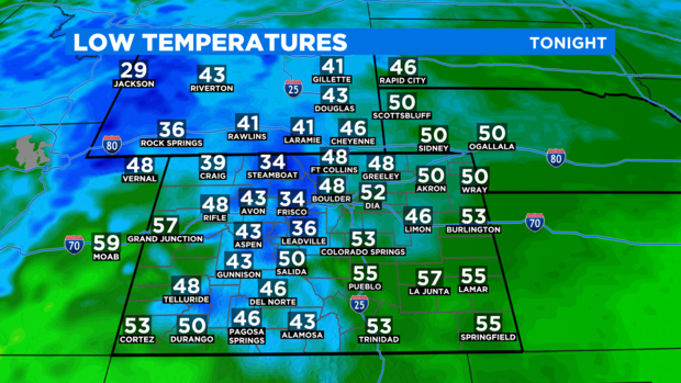
Meanwhile in Denver temperatures should actually be somewhat warmer Tuesday morning compared to Monday morning when Denver officially dropped to 46 degrees. It was the coolest morning since June 10.
The average first snow in Denver is October 18.