Denver Weather: Snow On The Way! Storm Will First Bring Rain This Afternoon
DENVER (CBS4) - A spring storm racing into Colorado on Friday will produce mountain snow, a mix of rain and snow for the metro area, and much cooler temperatures statewide to end the week.
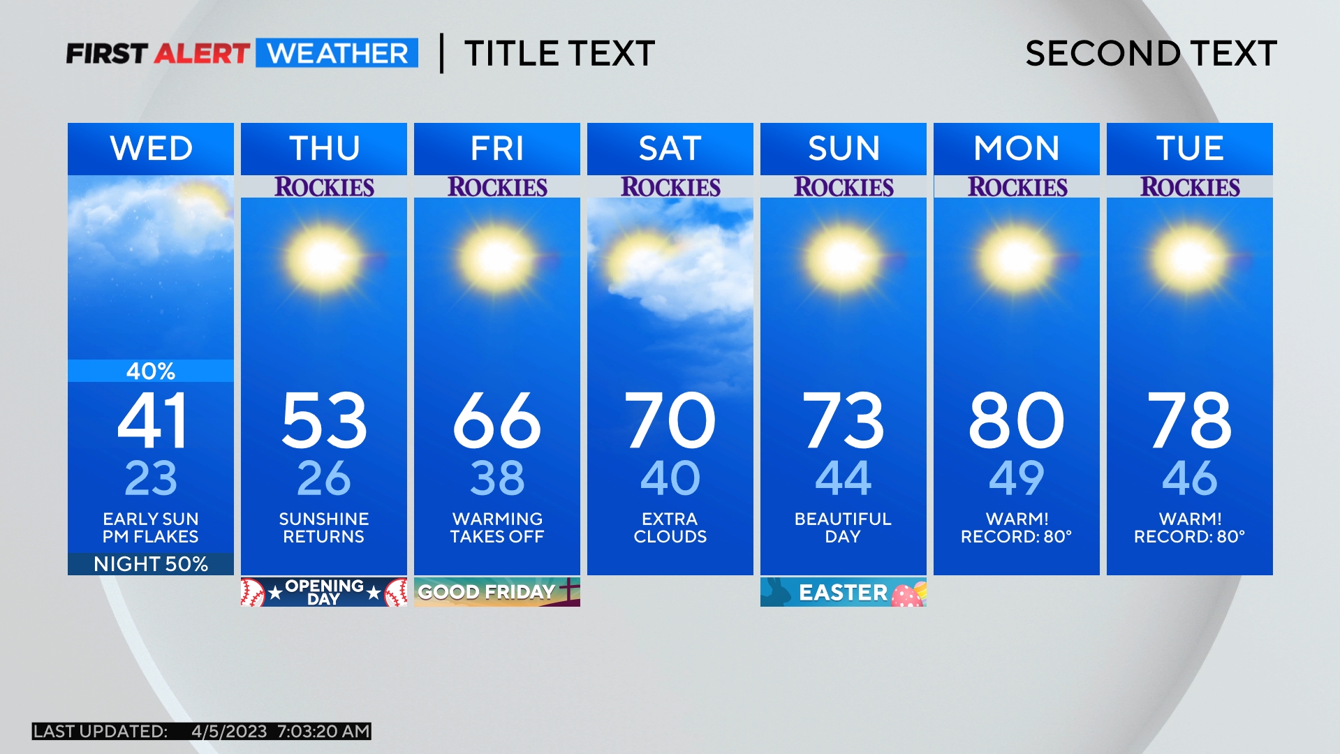
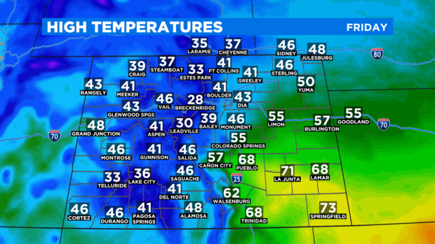
Afternoon temperatures around Denver, Boulder, and Fort Collins will be in the lower 40s Friday which is about 15 degrees below normal for the final week in March. It's also much colder compared to every other day this week. Highs have been in the 50s and 60s since last Sunday.
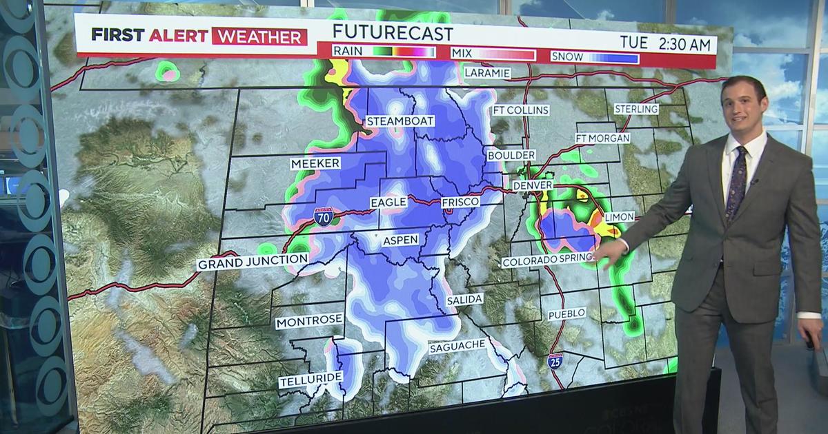
In the Denver metro area, Friday morning will include low clouds, fog, and drizzle. Then as the storm approaches in the afternoon, scattered rain showers will develop with small chance for thunder. Temperatures will become cold enough mainly after 5 p.m. for the rain to become snow and slushy accumulation is expected Friday night into very early Saturday morning.
Most locations below 6,000 feet in elevation including the vast majority of the Denver metro area, accumulation will be limited to just an inch or two of accumulation. A few areas could get up to 3 inches. Meanwhile, locations on the urban corridor above 6,000 feet including Castle Rock, Franktown, Elizabeth and the foothills of the Jefferson, Boulder, and Larimer Counties will generally get between 3 and 6 inches of wet snow.
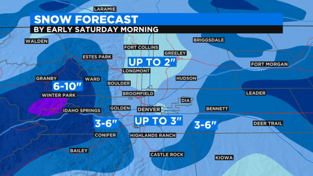
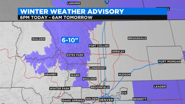
The mountains of Summit County and the Winter Park area will get 3-7 inches of snow while mountains farther north including the Rocky Mountain Park region will get up to 10 inches of snow. This area including Estes Park is under a Winter Weather Advisory through 6 a.m. Saturday.
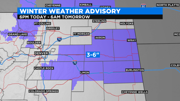
Also under a Winter Weather Advisory is a large section of the Eastern Plains including Limon, Akron, Wray, and Burlington. The storm is expected to strengthen as is moves east toward Kansas and therefore eastern Colorado will likely get heavier snow. Most of these areas will get 3-6 inches of slushy snow.
There are no advisories for the immediate Denver metro area because accumulation is generally expected to stay under 3 inches.
Saturday will technically be warmer than Friday and there will be more sunshine compared to Friday. But a stiff northwest wind will continue to make it feel chilly throughout the day. Gusts could easily reach 35 mph so it will feel quite a bit cooler than the 52 degrees we're advertising for Denver on Saturday. Sunday will be the better weather day this weekend.