Denver Weather: As Another Storm Arrives, Expect More Wind Than Anything Else
DENVER (CBS4) - Another storm will move slowly across Colorado through Saturday. And while some mountain areas will be measuring snow in feet, Denver and the Front Range will likely get more wind than precipitation with this storm.
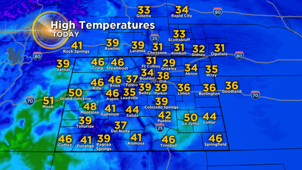
Temperatures will also be stuck below normal through the weekend. The normal high temperature in Denver on Thanksgiving is 49 degrees so temperatures will stay at least 10 degrees below normal with highs in the mid and upper 30s.
Thursday will also be mostly cloudy but dry along the Front Range and throughout most of the state. The exception is the southern mountains where snow is likely.
On Friday, the metro area could experience drizzle or very light rain in the afternoon followed by light snow Friday evening. Very little accumulation is expected and the bigger issue will likely be wind. Wind gusts in the Denver, Boulder, and Fort Collins areas could easily reach 45 mph from Friday afternoon through at least Saturday morning.
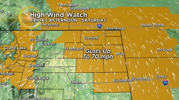
The plains east of the urban corridor and the foothills and mountains to the west will experience even stronger gusts. A HIGH WIND WATCH has been posted for the plains for gusts up to 70 mph along the I-76 and I-70 corridors east of Wiggins and Limon.
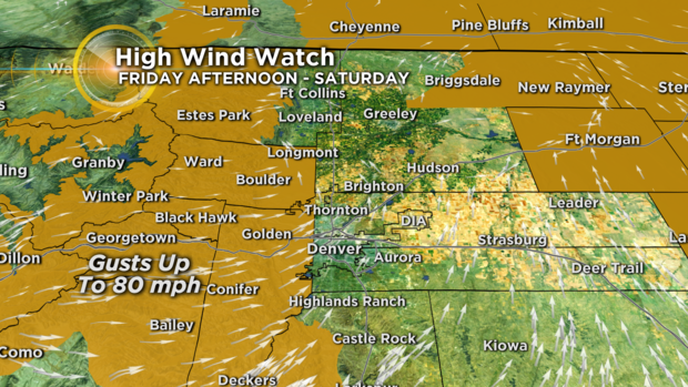
A HIGH WIND WATCH has also been posted for the foothills and mountains west of Denver, Boulder, and Fort Collins for gusts up to 80 mph from late Friday through late Saturday. That's hurricane force wind!
The mountains of Summit County and the Winter Park area will also get snow on Friday and Saturday but accumulation will be limited to 2-6 inches. So wind will likely have a bigger impact on travel compared to snow for mountain areas along and east of the Continental Divide.
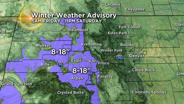
Meanwhile, wind won't be as strong for mountain areas farther west but snow accumulation will be much higher. The mountains surrounding Vail/Beaver Creek and Aspen/Snowmass as well as the Flat Tops and Rabbit Ears Pass area are under a Winter Weather Advisory from 5 a.m. Friday until 11 p.m. Saturday for 8 to 18 inches of snow.
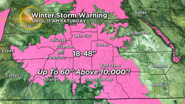
And in the San Juan Mountains, it's a Winter Storm Warning until 11 a.m. Saturday for widespread snow amounts between 18 and 48 inches of snow and up to 5 feet of accumulation for south-facing slopes above 10,000 feet. Needless to say, travel will become impossible in the southwest mountains of Colorado.
After the storm departs late Saturday, mostly sunny and cool weather is expected for the Broncos game on Sunday.