Farmers' Almanac Says Colorado Will Ride The 'Polar Coaster' This Winter
DENVER (CBS4) - The infamous Farmers' Almanac released their winter outlook this week and it paints a cold and wet picture for much of the nation. Colorado is included in an area marked frigid and snowy. The outlook is completely opposite of the most recent winter outlook published by NOAA's Climate Prediction Center.
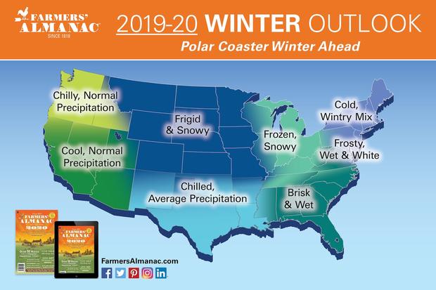
The Farmers' Almanac is predicting the coldest outbreak of the season should arrive sometime during the final week of January and last into the beginning of February. But that's not a surprising prediction because that is basic climatology for the Northern Hemisphere, where late January and early February are historically some of the coldest weeks of the year.
The almanac's reference to a "polar coaster" implies that we will experience a winter full of ups and downs when it comes to temperature, but for a mid-latitude location like the lower 48 United States, where the polar jet stream is a frequent visitor, that is pretty much what happens during the winter months.
Winter is defined by astronomy as being the period starting December 21, 2019 and ending March 19, 2020. The season is defined as the months of December, January and February in meteorology.
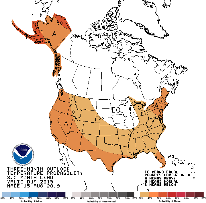
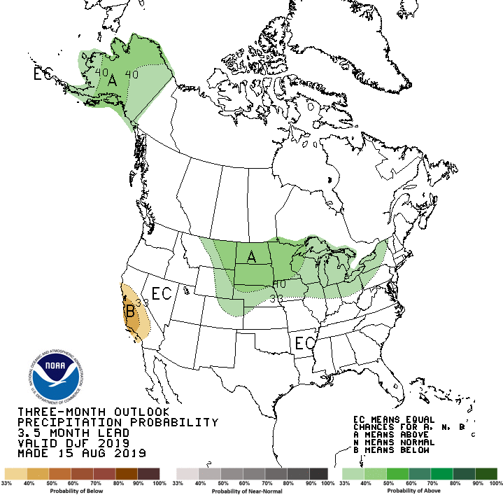
NOAA's most recent outlook produced by the Climate Prediction Center on August 15 calls for average to slightly above average temperatures for most of the nation with the potential to see well above average readings in Alaska. The Upper Midwest is labeled "EC" which means equal chances to see anything.
As far as precipitation goes the outlook from NOAA calls for wetter-than-normal conditions predicted for the Upper Midwest states, the Great Lakes region and for most of Alaska. The rest of the nation has equal chances to see anything with the possibility for drier-than-normal weather in parts of California, which wouldn't be good because winter is their rainy season.
When looking at winter outlooks it is important to note that a season is made up of approximately 90 days and averages are calculated using all of the daily data. So if for instance your area is predicted to see cold temperatures with a lot of snow, there could be 75-80 normal to warm days with 10-15 unusually cold ones mixed in, thus making the 90-day average end up being below normal, when in fact it didn't necessarily feel like a really cold winter.
The same thing goes for snow. An area could have a relatively dry winter but receive one or two large snowstorms and end up with more snow than normal.
Globally we are coming out of an El Niño event and the winter ahead is predicted to be what's called an ENSO-neutral phase, which means there are no specific trends indicated. In this case it's suggested to follow climatology and use the 30-year normals for a particular location when predicting what the upcoming winter may hold in store.
As always there will likely be at least one or two potent winter storms that move across the nation as they travel along the troughs and ridges associated with the Polar Jet Stream.