Positive Wildfire Outlook Following Big Snow Season
DENVER (CBS4) - Active April weather and widespread snow has not only alleviated our fire danger, it has removed it completely.
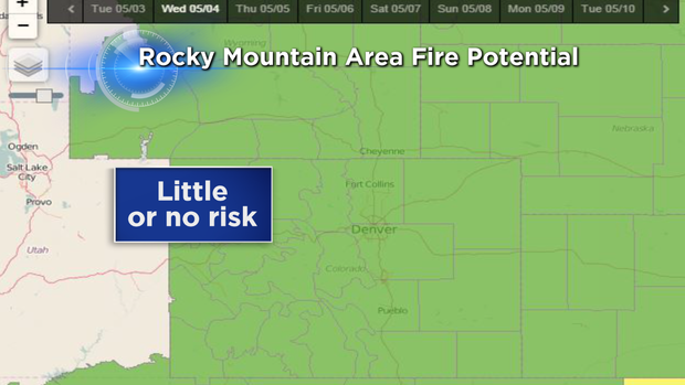
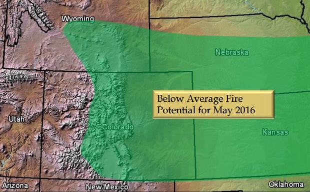
The latest Fire Weather Outlook from the Rocky Mountain Area Coordination Center shows "little to no risk" across the entire state of Colorado.
Percent of average snowpack, the short-term precipitation forecast, and current drought conditions are among several factors used to determine fire danger.
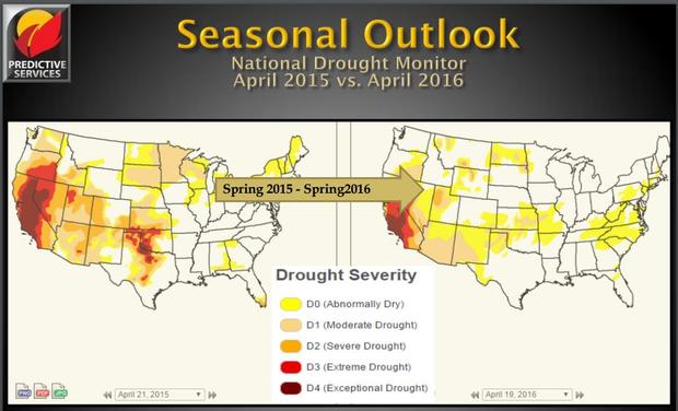
The U.S. Drought Monitor shows a year-to-year improvement in moisture as we enter Colorado's typical wildfire season. However, the southeast corner of the state has an "Abnormally Dry" rating, with parts of Las Animas County still struggling with "Moderate Drought" conditions.
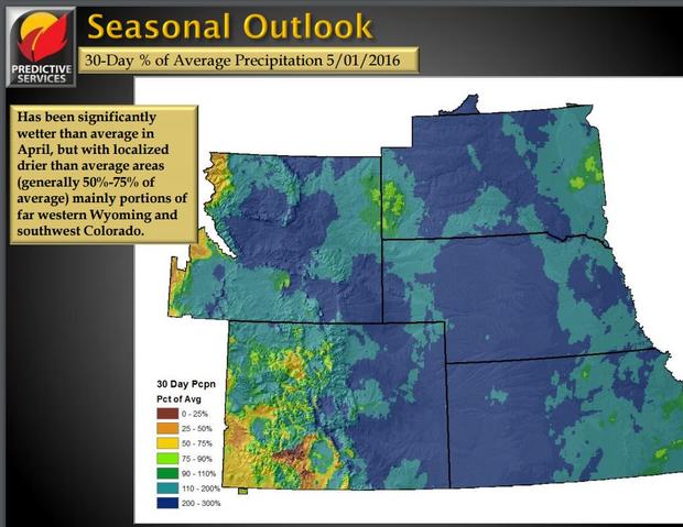
Snowfall has exceeded normal seasonal values across most of Colorado, and some locations have recorded as much as 200–300 percent more than average. Snow still covers the mountains west of the Continental Divide but runoff will increase as daytime temperatures warm through the end of May. The green-up has started in eastern Colorado where wetter-than-average conditions have eliminated the threat of an early onset to wildfire season.
Precipitation returns to the forecast this weekend with mountain snow and possible thunderstorms on the plains. If the weather pattern continues to bring regular rain and snow into the area, the Rocky Mountain Area Coordination Center is expecting a slightly below average wildfire season during the month of May.
One concern with a jump in fire danger would be if Colorado suddenly entered a dry period that allowed the vegetation to cure and become fuel. This would be a potential threat following an extended period of rainfall that supports more vegetation growth that normal.
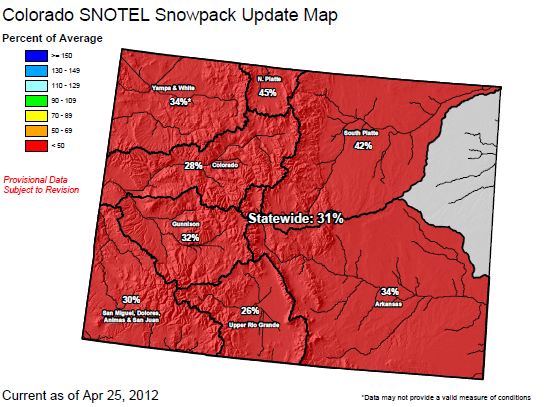
To use a recent example of how bad conditions can get, notice the abysmal snowpack during April of 2012. Our statewide average was only 31 percent of normal — compare that to 111 percent in 2016. This was the year of the Lower North Fork fire which destroyed 22 homes and torched over 1,400 acres.
While the low fire danger is very good news, the risk is never far away from the Front Range.
As we get deeper into the spring and summer months, just remember that it doesn't take long for wildfires to start if our moisture takes a break.
Wildfire Resources
- Visit CBSDenver.com's Living With Wildfire section.
Wildfire Photo Galleries
- See images from the most destructive wildfires (Black Forest, Waldo Canyon, High Park and Fourmile) and largest wildfire (Hayman) in Colorado history.
Justin McHeffey provides nightly reports from the Mobile Weather Lab. He travels Colorado in search of Mother Nature's most powerful and beautiful conditions. Like his Facebook page Meteorologist Justin McHeffey and follow him on Twitter @WeatherMcHeffey.