Unique Terrain Is Why Front Range Snow Totals Often Vary
DENVER (CBS4) - When you're a meteorologist in Colorado, making a snow forecast can be a tough chore.
Our state's varying terrain and elevation combine to create thousands of microclimates.
Denver lies in the South Platte River valley with an elevation of 5,280 feet.
Typically, in a big snow event, the heart of the city will see the least amount of snow.
The reason why lies in all the different terrain features that surround the city.
If a winter storm spins through and brings moisture and cold air straight from the north, then the south Denver metro area has the best chance to see heavier snow.
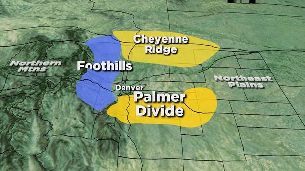
This includes places like Castle Rock, Highlands Ranch, Elizabeth and Parker, which lie along the Palmer Divide, an area between Denver and Colorado Springs that runs from the foothills east toward Limon.
As you leave downtown Denver and travel south over the Palmer Divide the elevation increases by more than 2,000 feet.
When the wind rocks this ridge out of the north, snow amounts can be huge compared to other locations.
A north wind is an upslope flow for the Palmer Divide, which helps to enhance precipitation.
These winds hit the slopes of the terrain and are forced to rise. The rising air cools and condenses, forming clouds and precipitation.
On Feb. 23, 2012, a storm socked the Palmer Divide with nearly a foot of snow while only an inch fell in Denver.
In the foothills west of Denver, where elevations average anywhere from 6,000 to 9,000 feet, it's a whole different scenario.
For the Front Range foothills to get slammed with heavy snow, we need a storm with a strong easterly wind to create upslope.
On Oct. 27, 2009, a powerful early-season storm loaded with moisture dropped up to a foot of snow over Denver, but up to four feet fell in the foothills, where precipitation was enhanced by upslope winds.
The northern part of the Front Range, including Fort Collins and Longmont, sit along a terrain feature called the Cheyenne Ridge, which is a high point that separates the South Platte River basin in northeast Colorado from the North Platte River basin in southeast Wyoming.
Elevations along the Cheyenne Ridge run as high as 7,400 feet.
Many Colorado cities and towns are in the shadow of this ridge and sometimes miss out on the heavy snow from the north, but can do really well if the flow of wind is blowing from the south or southeast, which is an upslope wind for the Cheyenne Ridge.
All of these different terrain features along the Front Range are why one side of town can be buried with up to a foot of snow while the other might receive little to nothing.