Half A Foot Of Rain Falls In Hours: See Latest Rain Totals
DENVER (CBS4) - Heavy monsoon rainfall created localized flash flooding and problems on the roads Tuesday, and more is in store today.
Rain totals have varied anywhere from a half inch to several inches over the past 24 hours.
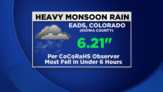
One of the highest rain totals we have seen so far in Colorado has come from the CoCoRaHS Climate Network, with 6.21 inches of rain measured in the small town of Eads, in Kiowa County.
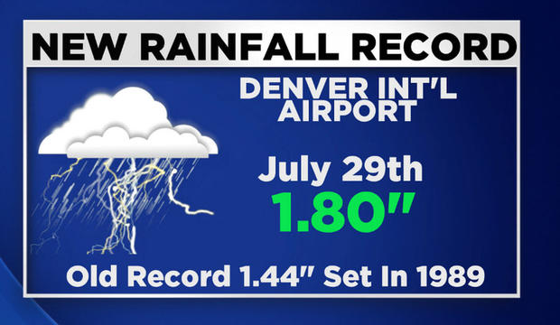
Denver International Airport recorded 1.80" of rain for July 29th, setting a new daily record that stood since 1989.
The town of Windsor saw over 3 inches of heavy rain Tuesday afternoon that caused streets and fields to flood quickly.
The fast moving waters poured into some nearby basements, leaving behind a lot of damage.
RELATED: Flooding In Windsor Shuts Down Streets, Soaks Basements
In drought stricken towns of southeast Colorado, including Eads, Lamar, Springfield and La Junta, several inches of rain created widespread flash flooding that shut down several roads for a brief time.
Flooding was also reported on the northeast plains in portions of Morgan, Washington and Yuma counties.
8 A.M. TOTALS
6.21" - 0.45 miles E of Eads (Kiowa County)
4.17" - 3.9 miles WNW of Greeley
3.80" - 2 miles NE of Idalia (Yuma County)
2.85" - 12 miles NNW of Two Buttes (Prowers County)
2.26" - 3.6 miles NNW of Denver
2.23" - 5.2 miles S of Denver
2.01" - 2 miles NNW of Golden
1.95" - 5.7 miles NW of Holyoke
7 A.M. TOTALS
4.25" - 6.1 miles ESE of Eads
4.02" - 0.1 miles NNW of Illif (Logan County)
3.92" - 10.1 miles N of Lamar
3.65" - 4 miles south of Towner (Kiowa County)
3.20" - 7.5 miles NW of Wellington
2.93" - 0.5 miles NW of Springfield
2.58" - 4.6 miles WNW of Greeley
2.50" - 10.3 miles W of Bellvue
1.54" - 7.2 miles SSW of Virginia Dale (Larimer County)
1.42" - 3.4 miles SE of Eaton (Weld County)
1.35" - 2.5 miles N of Steamboat Springs
1.33" - 3.3 miles NNW of Arvada
1.32" - 1.7 miles SW of Lakewood
6 A.M. TOTALS
3.54" - 1.0 mile SSE of Windsor
3.15" - 3.6 miles NNE of Vernon (Yuma County)
2.52" - 3.9 miles NNE of Black Forest (El Paso County)
2.49" - 2.5 miles SSW of Hillrose (Morgan County)
2.35" - 8.6 miles N of Sterling
2.22" - 1.8 miles NW of Sterling
2.13" - 7.5 miles NNW of Snyder (Morgan County)
2.10" - 4.2 miles WNW of Ramah (Elbert County)
1.74" - 0.9 miles ESE of Severance (Weld County)
1.71" - 1.2 miles WNW of Brush
5 A.M. TOTALS
2.13" - 7.5 miles NNW of Snyder (Morgan County)
1.71" - 1.2 miles WNW of Brush (Morgan County)
1.56" - 2.7 miles WSW of Colorado Springs
1.27" - 6.2 miles NE of Fort Morgan
1.18" - 12.5 miles NW of Golden
1.08" - 2.6 miles W of Greeley
1.05" - 2.7 miles SSE of Highlands Ranch
1.05" - Boulder
1.02" - 0.3 miles W of Limon
0.82" - 0.9 miles SSW of Arvada
0.81" - 3.7 miles ESE of Foxfield
0.80" - 3.0 miles N of Aurora
0.79" - SE Aurora near Quincy & Gun Club Road
0.75" - 1.9 miles ESE of Thornton
0.74" - 0.1 miles WNW of Swink (Otero County)
0.55" - 0.9 miles NE of Lafayette
0.49" - 2.2 miles ESE of Lakewood
Refresh this story throughout the morning for new totals as they come into the CBS4 Weather Center.