Top Scenic Drives In Colorado
Route of the Fourteeners
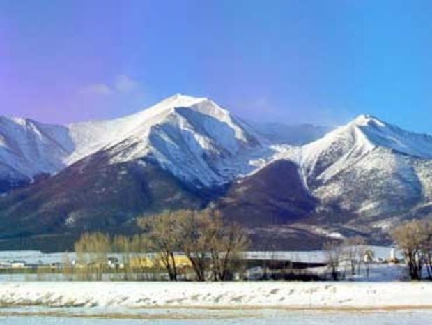
U.S. 24/285 between Leadville and Salida
Top of the Rockies National Scenic Byway
topoftherockiesbyway.org
Leadville Chamber of Commerce
leadville.com
Chaffee County Visitors Bureau
coloradoheadwaters.com
The 60 miles between the historic mining town of Leadville, the nation's highest incorporated city, and the temperate community of Salida, provides a procession of the sky-piercing 14,000-feet mountains of the Sawatch Range. The 14 tallest mountains lining the west side of this scenic route include Colorado's two highest, Mt. Massive and Mt. Elbert, and a quartet named after Ivy League colleges, Princeton, Yale, Columbia and Harvard, that have earned it the nickname, Route of the 14ers. Part of the drive is also congruent with the Top of the Rockies Byway. And it parallels the Arkansas River from its headwaters near Leadville to Salida, past some of the best-known rafting stretches in the land.
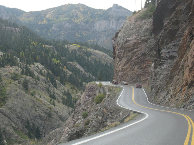
San Juan Skyway Scenic Byway
U.S. 160, CO 184, CO 145, CO 62, U.S. 550
colorado.com/Southwest
This 236-mile route loops around the southwestern Colorado's most spectacular mountains and through its most iconic towns. Starting in Durango and traveling clockwise, it passes through Cortez, Delores, Rico, Telluride, Ridgway, Ouray, Silverton, and back to Durango, crossing dramatic mountain passes, paralleling rushing rivers, skirting designated wilderness areas as well as legendary mining towns of the past. The eastern part of the loop includes the storied Million Dollar Highway (U.S. 550 between Silverton and Ouray) that provides 25 miles of the best San Juan mountain vistas. Though the entire stretch is called the Million Dollar Highway, the scenically richest part is the 12-mile Uncompahgre Gorge from Ouray to the top of Red Mountain Pass via a narrow road that threads past steep cliffs and slow-speed hairpin turns and views that won't quit.
San Luis Valley
U.S. 285, CO 17, U.S. 285/160, CO 159, CO 142, U.S. 285
colorado.com/SouthCentral
nps.gov/grsa/
This enormous valley between the San Juan Mountains to the west and the Sangre de Cristo to the east is, in many ways, the soul of Viejo Colorado. The town of San Luis was founded in 1851 in the southern part of the valley and is the state's oldest, and Kit Carson once commanded nearby Fort Garland. Coming down from Poncha Pass to the north, the valley appears to be pancake flat and featureless, but a drive through it reveals an agrarian landscape of grazing cattle, plowed fields and small rural villages. The valley holds myriad natural wonders, including the remarkable Great Sand Dunes National Park with shifting sands up to 750-feet-high that look like the Sahara Desert against a backdrop of snow-capped mountains. Wetlands attract birds, including the magnificent sand hill cranes that stop by the Alamosa and Monte Vista National Wildlife Refuges en route between their winter quarters in New Mexico and their summer range in Nebraska.
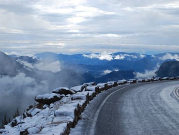
Trail Ridge Road
U.S. 36 between Estes Park and Grand Lake
Rocky Mountain National Park
rmnp.com/RMNP-Areas-TrailRidge
nps.gov/romo/
This 48-mile road through Rocky Mountain National Park is as seasonal as it is scenic. It closes for the winter when the snow starts flying and is cleared out, usually by Memorial Day, after powerful plows bore through deep, high-elevation snowfields. During the half of the year that it is passable, it provides panorama after panorama of magnificent mountains (including 14,225-foot Longs Peak visible to the south), glacier-carved valleys, broad meadows filled with brilliant wildflower and dramatic alpine tundra. It crosses the Continental Divide at Milner Pass but reaches its highpoint at 12,183 feet. Along the way are scenic overlooks, hiking trailheads and, at what feels like the top of the world, the park's Alpine Visitor Center.
Learn more about the Colorado Scenic and Historic Byways program at ColoradoByways.org. Visit Byways.org for more information on the National Scenic Byway program.
-- Mile High Cheapskates Claire Walter & Laura Daily keep Denver/Boulder residents informed about the latest deals, discounts and freebies at MileHighOnTheCheap.com