Forecasters Eye Snow Outlook As Colorado Snowpack Drops 5% In A Week
By Chris Spears
DENVER (CBS4) - Despite the fact that the 2015-16 snow season started off with a bang across Colorado, things aren't looking as good as they did just a few weeks ago.
Weather patterns that bring heavy mountain snow all but seem to have dried up since the beginning of February.
During that time snowpack fell from well over 100% in late January to 99 percent of the median by March 1.
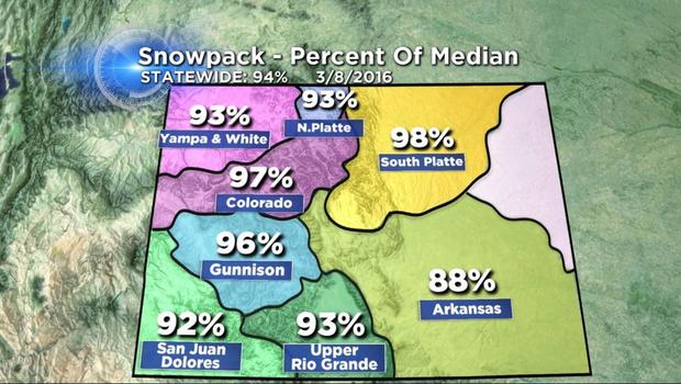
As of March 8 that number was down to 94 percent and falling fast.
Some of the largest changes have been experienced in southwest Colorado.
March and early April is the most critical period of time for snow accumulation in the central Rockies.
Historically we see the biggest storms of the year as spring weather patterns begin to develop.
And while there is still plenty of time for things to change, it's also time to raise an eyebrow and consider "what if" we don't see normal spring precipitation.

In 2015 Colorado saw a brief dry spell develop during February and early March before things turned very wet in April and May.
But in 2012 a dry spell that developed during late winter remained in place right through the summer and we saw several major wildfires as drought took over.
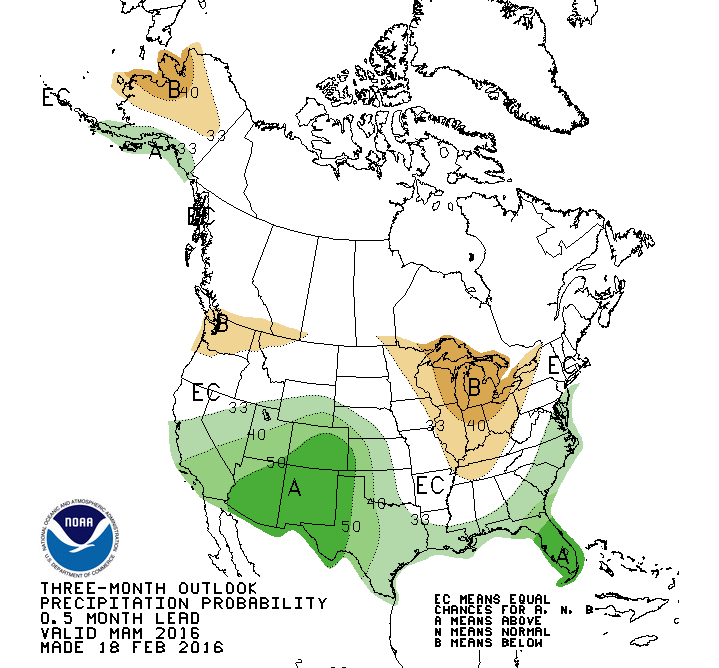
NOAA's Climate Prediction Center continues to indicate a wetter-than-normal climate outlook for Colorado heading into the early and middle part of spring so there is still hope for things to turn around and the season to end on a high note.
Meteorologist Chris Spears writes about stories related to weather and climate in Colorado. Check out his bio, connect with him on Facebook or follow him on Twitter @ChrisCBS4.