Colorado Snowpack Numbers On The Rise
Statewide snowpack averages are high as we round the corner of midwinter. The benefits are felt in the long-term just as they are in the immediate future. Skiing and snowboarding conditions are great. Frozen water storage for summer recreation is great. Wildfire danger gets suppressed in the coming months—although the risk is always present—as the mountains stay snow-covered. Ecosystems and wildlife thrive when the watersheds are where they should be. And indirectly, Colorado's tourism industry is influenced because so much revolves around the outdoors—especially when they look their best. It's a win–win from any angle.
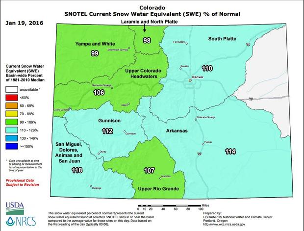
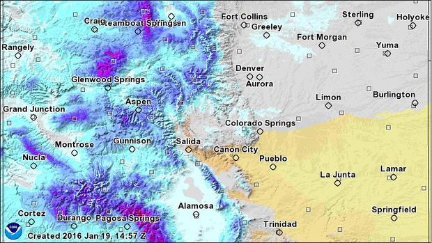
So where do we stand? As of Jan. 19, Colorado's statewide snowpack average is 108 percent of normal. In other words, greater than average snowfall by this point in the winter season if all drainage basins are averaged together. On the high-end, the San Miguel/Dolores/Animas/San Juan area has 118 percent snowpack. On the low-end, (and this is practically negligible) the North Platte basin has 98 percent of its year-to-date snowpack. Exactly one year ago the statewide average was 88 percent of normal. We weren't in dire straits, but the Upper Rio Grande (eastern San Juan Mountains) only had 65 percent at the time. That was enough to affect local streams, reservoirs, and obviously the ski areas in that part of the state.
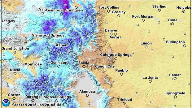
Taking a look at NOAA's remote sensing models, we see a clear picture about where the snow has stacked up this season. At first glance, there's just more snow on the ground this year compared to last year. But look more closely at the San Juan Mountains and you'll notice a substantial shift in the snowpack 2015 vs. 2016. In climatological terms, the southern third of the state is favored during El Niño episodes. Telluride has recorded 189" so far this season, last year at this time they had less than 140". Wolf Creek Ski Area has had 270" of snowfall so far this season. That's close to their total snowfall at the end of the 2015 season when the storm track favored mountains to the north.
Granted this post is being written after a few snowstorms, there's much more moisture on a number of the western slope's geographic areas. Take the Uncompahgre Plateau (north of Nucla) for example, last year it only had 2–4" of snow water equivalent (SWE) in its deepest snowpack. The same area is about 10–16" deep with frozen water this season.
The Flat Tops Wilderness north of Glenwood Springs shows a similar pattern. These mountains had around 10–14" SWE in 2015. Now, these mountains have 20" or more locked up as winter water storage. In both examples, the spring runoff becomes part of the Colorado River Basin. Good for fish, good for fires, good for reservoirs.
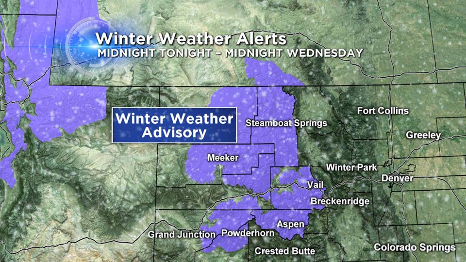
While it's too early to cast any confidence in the state's water storage next summer, the first month of winter has shown an encouraging trend. In a related story, the western and northwestern mountains are under a Winter Weather Advisory Tuesday through Wednesday night.
Justin McHeffey provides nightly reports from the Mobile Weather Lab. He travels Colorado in search of Mother Nature's most powerful and beautiful conditions. Like his Facebook page Meteorologist Justin McHeffey and follow him on Twitter @WeatherMcHeffey.