This Week In Denver Weather History: Winds Near 150mph Hit Boulder
DENVER (CBS4) - The Front Range foothills are known for high wind events during January, but nothing like what hit the region 33 years ago.
A ferocious storm blew into Boulder just after midnight on Jan. 17, 1982, with several hours of hurricane force gusts.
At the National Center for Atmospheric Research, there were 20 gusts of wind over 120 mph between 1 and 9 a.m. that damaged 40 percent of the buildings in Boulder and caused 20 million dollars in damage.
On Jan. 11-14, 1997, a bitter cold air mass settled along the Front Range leaving a fresh layer of snow.
Thermometers fell below zero for 60 consecutive hours in Denver.
In 2001, a snow storm hit on the 15th and 16th, causing a crash on Interstate 25 near Castle Rock that involved over two dozen cars.
One person lost their life and a dozen others were injured.
Here are more highlights from this week in Denver weather history.
- Jan. 10-13, 1963 - Much of the region was in the middle of an icy grip with sub-zero temperatures. In Denver, the thermometer was below zero for 64 consecutive hours. The low hit -25°F on both the 11th and 12th and the high on the 9th was -9°F at Stapleton Airport which tied the coldest daytime high on record for the month of January. A teenager in Denver died from exposure to the cold and there was heavy damage to homes and businesses from frozen water pipes.
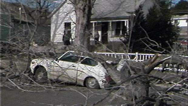
- Jan. 11-12, 1972 - High winds hit the Front Range with a gust of 144 mph recorded at the National Center for Atmospheric Research in Boulder. Winds hit 105 mph at Rocky Flats and 90 mph in downtown Boulder. Over two dozen mobile homes in Boulder were damaged or destroyed, numerous car windows were shattered and traffic lights were blown down. A dozen people were injured by flying glass and treated at local hospitals.
- Jan. 13-14, 1960 - A snowstorm hit eastern Colorado with 4.4 inches and wind gusts near 30 mph at Stapleton Airport. In southeast Colorado the snow and wind combined to create drifts up to 6 feet deep.
- Jan. 14, 1875 - A strong Chinook wind brought a welcome warm-up to Denver. At 9 p.m. the weather observer measured a temperature of 1°F. By 9:15 p.m. the winds picked up out of the southwest and warmed the temperature to 19°F. By 9:20 p.m. it was 26°F and by 9:30 p.m. it was 36°F. The warming didn't stop there. By 9:35 p.m. it was 40°F and it was 49°F by 10 p.m. that night.
- Jan. 14-15, 1999 - High winds hit metro Denver with a gust of 108 mph in Wondervu, 80 mph in Evergreen at the Hiwan Golf Course, 76 mph in Aspen Springs, 75 mph at the JeffCo Airport, 74 mph in Boulder, 70 mph at Georgetown and 48 mph at Denver International Airport. Over 600 homes in the Commerce City area lost power when three utility poles were knocked down.
- Jan. 14-21, 1930 - A bitter cold air mass invaded Colorado with temperatures in the Denver area falling below zero 8 nights in a row.
- Jan. 15, 1875 - The wind in Denver shifted from the southwest to the northeast and pulled much colder air into the city. The temperature dropped from 52°F to 4°F between 11:30 a.m. and 12:30 p.m.
- Jan. 15, 1987 - A heavy January snow hit metro Denver with a variety of totals ranging from 3 inches in southeast Aurora to 18 inches in the foothills and western suburbs. Castle Rock saw a half inch of snow while Denver officially measured 10.3 inches at Stapleton Airport.
- Jan. 15-16, 1967 - A severe windstorm hit Boulder with winds reaching 125 mph at the National Center for Atmospheric Research and 84 mph downtown. Damage totaled a half million dollars.
- Jan. 15-23, 1962 - A cold snap hit Colorado with temperature in Denver falling to or below zero on 9 consecutive nights. The severe cold damaged numerous water systems. Several traffic accidents and heart-attacks were attributed to the winter blast. A woman froze to death in Morrison.
- Jan. 16, 1911 and 1935 - A rare January rainfall was reported with a trace measured in the city.
- Jan. 16-18, 2011 - A very strong jet stream produced widespread blizzard conditions in the mountains above tree line. Gusts reached 99 mph on Loveland Pass, 80 mph on Berthoud Pass and 79 mph on Niwot Ridge.
- Jan. 17, 1990 - A freak snowstorm hit Boulder County catching many off guard. It dumped 3 to 6 inches of snow during a three hour period in a swath about 20 to 30 miles wide, stretching from near Boulder to just northeast of Longmont.
- Jan. 17-18, 2012 - A severe windstorm hit the Front Range knocking down trees and power lines that damaged homes and automobiles. A semi-trailer was blown on its side near Marshall along Highway 93 where gusts were clocked at 92 mph. Gusts in south Boulder reached 104 mph, 73 mph near Lyons, 62 mph in Superior and 61 mph in Erie.