Tornado Warnings, Severe Storms Move Along Front Range
DENVER (CBS4)- Severe storms moved through the Denver metro area, northeast of the Denver metro area and along the Front Range on Wednesday afternoon.
A tornado watch remained in effect until 8 p.m. for Adams, Arapahoe, Boulder, Broomfield, Denver, Douglas, Elbert, Jefferson, Larimer, Morgan and Weld Counties.
There was a confirmed tornado on the ground at Tower and Smith Roads. The Mobile Weather Lab tracked the storm through hail storms, heavy rain and the area where the tornado touched down.
There was also a report of a tornado on the ground in Watkins.
A severe thunderstorm warning was issued for north central Arapahoe County and south central Adams County until 5 p.m.
The storm was expected to bring heavy rain and up to golf ball sized hail. Hail was piled up several inches deep in the Denver neighborhood at 33rd and Olive.
There were no reports of any serious injuries. The hail didn't cause any serious damage but heavy rain caused a lot of flash flooding in several different neighborhoods.
A severe thunderstorm watch remained in effect until 8 p.m. for Baca, Bent, Crowley, El Paso, Huerfano, Kiowa, Las Animas, Otero, Prowers and Pueblo Counties.
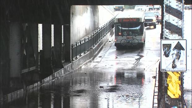
Highway 85 was closed in both directions through Commerce City where storms left behind dangerous driving conditions.
The basement of the city hall in Commerce City was flooded. There are several power outages at intersections along Hwy. 85.
A water rescue was performed on occupants of a vehicle stranded in standing water on 38th Avenue near Brighton Boulevard.
Firefighters say to stay away from standing water and don't attempt to drive through it. The water may be too deep to allow your car to cross safely; move to higher ground.
Excessive runoff from heavy rainfall will cause elevated levels on small creeks and streams and ponding of water in urban areas, highways, streets and underpasses as well as other poor drainage areas and low-lying spots.

The storm was headed northeast from the Denver metro area towards Bennett, Keenesburg, and Watkins.
Hail fell in Green Valley Ranch, Commerce City and parts of Denver, especially at Interstate 70 and Quebec which caused traffic delays.
PHOTO GALLERY: Severe Storms Wednesday, May 21
People are getting creative in finding ways to clear that hail that's piling up on sidewalks, in streets and along driveways and on lawns. Some were using snow shovels and others broke out the snowblowers to clear that hail before it melted.
The Cherry Creek Mall was closed for a while and shoppers, employees and mall staff were directed to tornado shelter.
The ground stop at Denver International Airport is over and flights resumed although passengers could expect lingering delays of 90 minutes in order for the airlines to catch up on the backup of planes waiting to take off.
United Airlines diverted about 25 flights. Colorado Springs received 10 flight diversions as of 3:20 p.m.
Students in some schools in Denver Public Schools sought shelter in interior hallways in the lowest level of the buildings, away from windows and glass. Schools in the northeast, northwest, downtown area and some schools in the southeast were placed on shelter place mode until the tornado warning was lifted.
Minor flooding was reported along I-25 from downtown Colorado Springs north to the Air Force Academy and on many side streets around the downtown area.