Looming Weekend Storm Means Keeping Close Eye On Flood Threat
DENVER (CBS4) - It's probably not what residents of the Front Range foothills want to hear, especially those living near rivers and streams that flooded last September.
But a spring storm is taking shape for the coming weekend, and it could bring a hefty amount of rain and snow.
FORECAST MODELS
Long-range forecast models have been showing the possibility of a potent storm since Monday. But as usual, there's still quite a bit of variation among the different forecast solutions.
Although it's a bit too early to provide specific forecast details, there are two trends that have been consistently showing up...
- this storm has the potential to bring a lot of water - possibly up to an inch of moisture for some places
- it will be somewhere in the central Rockies - some models show the storm over southeast Colorado, which would really favor Denver and the Front Range foothills - while others show it over southeast Wyoming, which would mostly just have an impact in some of our mountains
KEEPING A CLOSE EYE ON FLOOD THREATThe flood zones already have a much higher than normal potential to see spring flooding simply because there was so much snow accumulation in the mountains this past winter.
In addition, there is a long list of "unknowns" in areas hardest hit by last year's historical flood, such as how will streams behave as waters rise, especially those that saw so much physical change as the flood waters roared through.
Now, with the potential for even more rain and snow, it only adds to the list of growing concern.
WILL THERE BE SHORT TERM FLOODING PROBLEMS WITH THIS STORM?
That's a good question! A lot of it depends on the exact track, and if we see more rain than snow.
In the short term, the best case scenario would be to see snow in the foothills.
And while more snow could create bigger problems down the road, it buys some time, especially depending on what temperatures do in the next several weeks.
But if this next storm were to bring more rain than snow to the higher elevations, it could cause streams to rise quickly. Not only would we be dealing with runoff from the rainfall, but rain falling on top of snowpack will accelerate the melting process.
DO I CHANGE MY PLANS THIS WEEKEND?
Regardless of what happens, at this time, it looks like most of Saturday will be fairly decent. Rain and snow will be on the increase in the mountains.
As far as Sunday, there's still enough uncertainty with the storm track that it may be premature to change any plans.
However, just keep in mind that with the right track, the second half of the weekend could be soggy and unsettled.
WHAT IF I LIVE IN THE FLOOD PRONE AREAS OF THE FOOTHILLS?
If you live in these areas, you already have an elevated flood threat regardless of what happens with this storm system.
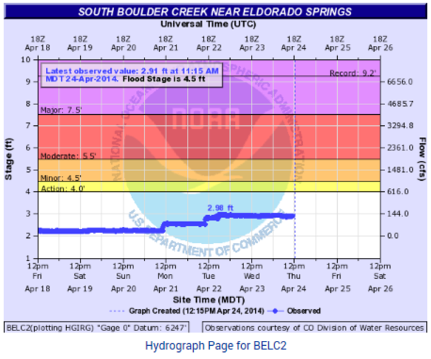
The following graph shows water levels on Boulder Creek near Eldorado Springs at 11:15 a.m. on April 24, 2014. The flood stage at that location is 4.5 feet, and the latest level was reading 2.98 feet.
With each passing day, rivers, creeks and streams in the foothills are starting to flow faster and show signs of rising with the snowmelt process underway.
So with the chance for precipitation in the forecast, and given that water levels are already rising without any additional rain or snow, it's definitely time to be vigilant in these areas, and have a plan in place for what to do should waters rise quickly and a flood potentially occur.